9:18 am
Correlator 3D, Drone, drone data, drone mapping, Drone News Feeds, Feature 1, News, SimActive
image courtesy SimActive Canada-based SimActive isn’t just a drone company. But as one of the global leaders in photogrammetry, SimActive sees drones as a key element in democratizing mapping data. In 2003, when Philippe Simard and his younger brother Louis started SimActive, the Canadian army was engaged in Afghanistan, mapping …
Read More »
11:32 am
3d mapping, agriculture drone, Applications, Drone, drone cameras, drone surveying, Featured - Agriculture, Featured - Products, Featured - Surveying, Imaging, jeff Fagerman, lidarausa.com, Mining, Mining and Construction, philippe simard, SimActive
SimActive Inc., recently announces the expansion of its network of resellers for medium format licenses. The new strategic alliances allow them to address the growing market need for processing imagery from medium format sensors. Partners include firms such as LiDARUSA, who offers SimActive’s Correlator3D™ to complement Phase One cameras. This …
Read More »
11:09 pm
Applications, Drone, Drone News, First Base Solutions, SimActive, Sponsored Content
Today SimActive., a world-leading developer of photogrammetry software is being use for a large-scale project by First Base Solutions who provides aerial imagery, geospatial data and custom mapping solutions to organizations across North America. The size of each image consisted of MB totaling 40 TB of raw data. As Drones are …
Read More »
4:59 pm
Drone, drone mapping, Drone News Feeds, Drones For Good, drones photogrammetry, Feature 1, geospatial data, Midwest Aerial Photography, News, SimActive
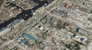
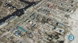
Disaster response efforts following Hurricane Michael have showcased high precision drone geospatial data. SimActive, a world-leading developer of photogrammetry software, partnered with drone service provider Midwest Aerial to perform critical damage assessment of homes and infrastructure after Hurricane Michael struck the Gulf Coast last month. Hurricane Michael destroyed billions of …
Read More »
11:39 pm
3D modeling, Commercial Drones, Drone, drone mapping, drone modeling, drones in construction, News, SimActive
SimActive‘s Correlator3D is one of the tools that enables commercial drone operators to level up and play at the enterprise level. SimActive has been a major player in the creation of photogrammetry solutions from aerial data since 2003. They started by utilizing data from satellites and manned aircraft, and their …
Read More »
10:09 am
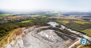
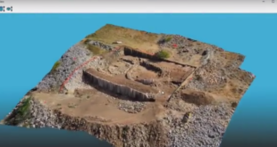
Alietum Ltd., commercial drone software., Correlator 3D, Drone, drone mapping, Drone News Feeds, drones in mining, Featured - Mining, mining drones, News, photogrammetry, SimActive
SimActive Inc. is a world-leading developer of photogrammetry software – for drones and for manned aircraft. It’s a professional tool that provides the speed and precision big business expects. SimActive’s Correlator 3D software takes data from any sensor and uses one software interface for processing. Now, SimActive introduces new features …
Read More »
3:46 pm
3DR, ANRA, Drone, DroneDeploy, droneinsurance, DroneLaw, Enrico Shaeffer, Feature 1, flir, Genius NY, Interdrone, News, SimActive
Image: SimActive InterDrone – held Sept. 5-7 in Las Vegas this year -is getting close. There is so much to see and learn at the biggest commercial drone event in North America that planning is a good idea. We surveyed our partners to see what they were offering this year …
Read More »
2:08 pm
3d mapping, 3D modeling, Agriculture, commercial mapping software, Construction, Drone, drone surveying, industrial mapping software, mapping software, News, SimActive, Sponsored Content
Creating 3D fashions and maps from aerial footage isn’t a new concept. Sophisticated, survey grade fashions from satellite tv for pc and plane photos have been used for big scale environmental surveys, building initiatives, and different purposes. That performance is extremely priceless – and till just lately, reserved for presidency …
Read More »