2:32 pm
Correlator 3D, Drone, Drone News Feeds, drones in construction, News, SimActive
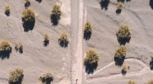
Drone mapping in construction can provide construction firms with the data they need to make profitable decisions. Chasco Constructors started in Round Rock, TX as a 4-man shop: but today, Chasco is an award winning, full service commercial construction company with over 300 employees. They’re using cutting edge technology, including …
Read More »
8:00 pm
Correlator 3D, Dawson Geophysics, Drone, Drone News Feeds, drones in oil and gas, energy drones, News, SimActive
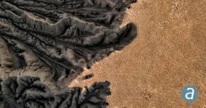
Canada’s SimActive and Dawson Geophysical demonstrate the use of drones with mapping and modeling software for oil and gas seismic exploration. Knowing where to drill is a million dollar question for the oil and gas industry. Seismic exploration is one way that the energy industry can determine where commercially viable …
Read More »
1:05 am
Applications, Business and Finance, Correlator 3D, data analytics, Drone, Drones in the News, Mining, Mining and Construction, multispectral imagery, News, Products, SimActive, Sponsored Content
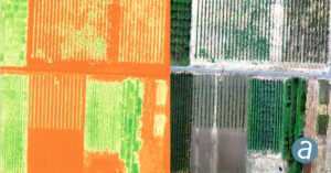
Montreal, Canada, June 9th, 2020 – SimActive Inc., a world-leading developer of photogrammetry software, announces the release of Correlator3D version 8.5. The new version allows users to share and visualize projects in the cloud. It also features new tools for the calibration and processing of multispectral imagery. Specifically, results can …
Read More »
4:33 pm
Correlator 3D, Drone, mica sense, multispectral imaging, News, SimActive
Image from MicaSense RedEdge USGS Unmanned Aircraft Systems [CC BY 2.0] Data gathered from sophisticated sensors requires sophisticated processing. Now, SimActive Inc., a leading developer of photogrammetry software, has announces the release of Correlator3D™ version 8.2 – which provides advanced processing capabilities of multispectral imagery. Correlator3D’s new version registers multispectral as well …
Read More »
2:22 pm
Correlator 3D, Drone, SimActive, Uncategorized, Wingtra
When it comes to enterprise drone applications, it’s all about the data – and the drone. Swiss provider Wingtra, a leading provider of VTOL hybrid drones for industry, has partnered with SimActive, the makers of Correlator 3D software, to offer customers rapid processing of high accuracy maps and survey data. …
Read More »
9:18 am
Correlator 3D, Drone, drone data, drone mapping, Drone News Feeds, Feature 1, News, SimActive
image courtesy SimActive Canada-based SimActive isn’t just a drone company. But as one of the global leaders in photogrammetry, SimActive sees drones as a key element in democratizing mapping data. In 2003, when Philippe Simard and his younger brother Louis started SimActive, the Canadian army was engaged in Afghanistan, mapping …
Read More »
10:09 am
Alietum Ltd., commercial drone software., Correlator 3D, Drone, drone mapping, Drone News Feeds, drones in mining, Featured - Mining, mining drones, News, photogrammetry, SimActive
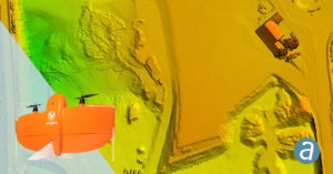
SimActive Inc. is a world-leading developer of photogrammetry software – for drones and for manned aircraft. It’s a professional tool that provides the speed and precision big business expects. SimActive’s Correlator 3D software takes data from any sensor and uses one software interface for processing. Now, SimActive introduces new features …
Read More »