12:23 am
correlator3d, Drone, drone mapping, Drone News, Drone News Feeds, News, Phase One IIQ, SimActive
SimActive and Phase One IIQ Announce Integration in Correlator 3D Version 9.2 SimActive Inc.’s Correlator 3D photogrammetry software is designed for large mapping projects. Phase One, a pioneer of digital imaging sensors and airborne systems, are a leading tool for data capture. Now, SimActive and Phase One have partnered on …
Read More »
2:32 pm
Correlator 3D, Drone, Drone News Feeds, drones in construction, News, SimActive
Drone mapping in construction can provide construction firms with the data they need to make profitable decisions. Chasco Constructors started in Round Rock, TX as a 4-man shop: but today, Chasco is an award winning, full service commercial construction company with over 300 employees. They’re using cutting edge technology, including …
Read More »
1:53 pm
Drone, drone mapping, Drone News Feeds, LIDAR, News, philippe simard, SimActive
Canadian mapping platform SimActive has added some significant new capabilities this year, including colorized point clouds and reflective calibration. CEO Philippe Simard explains what these features are – and how clients are using them. SimActive releases new features regularly. “With our user base growing exponentially, we are constantly monitoring how our …
Read More »
6:38 pm
Drone, drone data, drone LiDAR, drone mapping, Drone News Feeds, drone photogrammetry, LIDAR, News, photogrammetry, SimActive
Drone-based mapping and LiDAR are a powerful combination. Now, Canada’s SimActive Inc., a leading developer of photogrammetry software that can accommodate aerial imagery from satellite, manned aircraft, or drones, announces the integration of its Correlator3D™ product into LiDAR systems for drones developed by LiDAR USA. LiDARUSA, also known as Fagerman Technologies, …
Read More »
7:47 pm
correlator3d, Drone, drone mapping, Drone News Feeds, photogrammetry, SimActive
SimActive‘s new version of Correlator 3D, version 8.6, is feature-rich – making mapping from aerial images easier and more accurate all the time. Canada’s SimActive is a photogrammetry software that began as a solution for aerial images from satellite and manned aircraft. The inclusion of drone data in the solution …
Read More »
6:39 pm
Drone, drone mapping, News, philippe simard, SimActive, Sponsored Content
The following is a guest post by Philippe Simard, Ph.D., President of SimActive, Inc. Global Trends in the Mapping Industry during the Pandemic The pandemic has brough uncertainties to all businesses and the mapping industry has been no exception. Slowdowns were observed during the first few months of 2020 as …
Read More »
8:00 pm
Correlator 3D, Dawson Geophysics, Drone, Drone News Feeds, drones in oil and gas, energy drones, News, SimActive
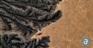
Canada’s SimActive and Dawson Geophysical demonstrate the use of drones with mapping and modeling software for oil and gas seismic exploration. Knowing where to drill is a million dollar question for the oil and gas industry. Seismic exploration is one way that the energy industry can determine where commercially viable …
Read More »
1:05 am
Applications, Business and Finance, Correlator 3D, data analytics, Drone, Drones in the News, Mining, Mining and Construction, multispectral imagery, News, Products, SimActive, Sponsored Content
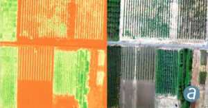
Montreal, Canada, June 9th, 2020 – SimActive Inc., a world-leading developer of photogrammetry software, announces the release of Correlator3D version 8.5. The new version allows users to share and visualize projects in the cloud. It also features new tools for the calibration and processing of multispectral imagery. Specifically, results can …
Read More »
8:46 am
Applications, Drone, Drone Mapping of UNESCO Archaeological Site, Drone News, Drone News Feeds, News, SimActive, Sponsored Content
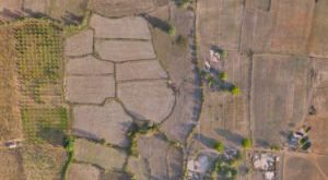
Drone Mapping of UNESCO Archaeological Site: From Simactive Drones mapping of UNESCO Archaeological sites are helping to gather the necessary data to help prepare orthophoto maps and digital elevation models of valuable areas. The drone mapping company SimActive recently announced that it is involved in the mapping of a UNESCO …
Read More »
6:46 pm
3d correlator, Applications, Drone, NEO, News, SimActive
In a recent press release, SimActive Inc., a world-leading developer of photogrammetry software, announces that their Correlator3D™ product is being used by Dutch company NEO B.V. to assess solar potential in multiple cities. Digital surface models (DSMs) are generated from WorldView and GeoEye satellite stereo images and serve to calculate …
Read More »