7:13 pm
Commercial Drones, Draganfly, Drone, Drone News, Drone News Feeds, heavy lift drones, LIDAR, News, North American-made drones
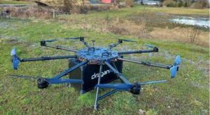
At Commercial UAV Expo in Las Vegas, commercial drone company Draganfly unveiled three new products: a Long Range LiDAR system which can be used as a mobile LiDAR system on drones, manned aircraft, or mounted to another vehicle or backpack; a North American-made Heavy Lift Drone, and the smaller “Swiss …
Read More »
8:26 pm
Censys, Drone, Drone News, Drone News Feeds, endurance drones, industrial drones, LIDAR, News, Products, Sensors
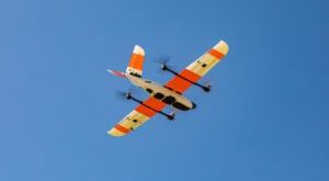
Censys Sentaero BVLOS Fixed Wing Censys Technologies Adds LiDAR To Payload Options by DRONELIFE Staff Writer Ian M Crosby Censys Technologies, a leading developer of beyond visual line of sight (BVLOS) unmanned aerial systems, is incorporating LiDAR into its offering of universal payload options. Continue reading below, or listen: Censys …
Read More »
1:59 pm
DL Exclusive, Drone, drone imaging, Drone News, Drone News Feeds, drones for agriculture, drones for conservation, Feature 1, Imaging, LIDAR, Lidar drone applications, News, Products, Quantum-Systems, Selected - Products, Sensors, Sony, wildlife international
Drones equipped with high resolution lenses are a powerful tool in the fight to protect wildlife around the world. Here, Yasuo Baba of Sony Digital Imaging gives us the specifics of the project between Quantum-Systems and Wilderness International. The following is a guest post by Yasuo Baba, Director, Digital Imaging …
Read More »
4:06 pm
Drone, drone LiDAR, Drone News Feeds, LIDAR, LiDAR surveys, News, Routescene, Skyfront
created by DJI camera Used for creating precise 3D models of terrain for mapping and more, LiDAR surveys are an important commercial application for the drone industry – but battery limitations and the associated short flight times remain a problem. Now, California-based Skyfront is working with European UAV LiDAR solution …
Read More »
1:53 pm
Drone, drone mapping, Drone News Feeds, LIDAR, News, philippe simard, SimActive
Canadian mapping platform SimActive has added some significant new capabilities this year, including colorized point clouds and reflective calibration. CEO Philippe Simard explains what these features are – and how clients are using them. SimActive releases new features regularly. “With our user base growing exponentially, we are constantly monitoring how our …
Read More »
6:38 pm
Drone, drone data, drone LiDAR, drone mapping, Drone News Feeds, drone photogrammetry, LIDAR, News, photogrammetry, SimActive
Drone-based mapping and LiDAR are a powerful combination. Now, Canada’s SimActive Inc., a leading developer of photogrammetry software that can accommodate aerial imagery from satellite, manned aircraft, or drones, announces the integration of its Correlator3D™ product into LiDAR systems for drones developed by LiDAR USA. LiDARUSA, also known as Fagerman Technologies, …
Read More »
12:04 pm
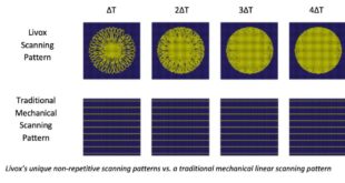
Business and Finance, ces 2020, DJI, Drone, Drone News Feeds, LIDAR, livox, News, Technology
As you’d expect, DJI has a big presence at this year’s Consumer Electronics Show (CES). But on top of showing off the company’s hardware lineup and handheld imaging systems, the drone industry’s leading manufacturer is introducing a success story from its Open Innovation Program: Livox. Livox has big ambitions in …
Read More »
12:44 pm
Aerospace, Agriculture, Applications, Auto, Business and Finance, Chemical, Construction, Defense, Delivery, Drone, Drone News, Education, Entertainment, Healthcare, Insurance, LIDAR, Mining and Aggregates, News, SimActive
SimActive has just announced some additional functionality removes some of the manual processes currently needed to process softificated imagery. From their press release below: “Removing the need to manually tag GCPs facilitates the integration of LiDAR data with imagery”, said Dr Philippe Simard, President of SimActive. “Our clients can benefit …
Read More »
6:16 pm
Drone, Drone News Feeds, Drones for Construction, Feature 1, Featured - Surveying, LIDAR, News, Products, Ryan LaDue, Sensors
Avalanche photodiode sensors. If you don’t know what they are – you need to. The following is a guest post by talented author and self-described nerd Ryan LaDue. The Latest Wave of Sensor Tech Could be a Game-Changer for LiDAR-Equipped UAVs Avalanche photodiode sensors are semiconductors capable of converting photons …
Read More »
1:21 pm
commercial drone, Drone, Feature 1, Finding Lost Gold, History Channel, LIDAR, News, PrecisionHawk
image: The History Channel Tonight’s the night for Episode 2 of the History Channel’s fascinating adventure: Lost Gold of World War II. This episode has an added interest for the drone industry, as a drone pilot and two data scientists from leading drone firm PrecisionHawk used LiDAR-equipped drones to help …
Read More »