12:45 pm
3d model, cave, Drone, Drone News, Enthusiasts, exploration, Featured - Mining, GPS, Iceland, LIDAR, mapping, Mining and Aggregates, navigation, News, seti institute, Technology
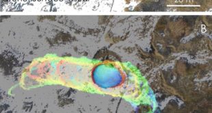
The SETI Institute is probably best known for its work scanning the stars for signs of extraterrestrial communications. But the organization’s remit is broader than that. Its many research teams work towards a noble goal: to explore, understand, and explain the origin and nature of life in the universe. Exploring …
Read More »
10:19 am
Conservation, dominican republic, Drone, Drone News Feeds, drones, Drones in the News, dronesforgood, earbot, Enthusiasts, expedition, Featured, LIDAR, News, Ocean Alliance, parley, Science, Snotbot, Technology
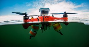
If you follow how drones are being used in the world of conservation, you will have heard about Ocean Alliance by now. The Massachusetts-based marine conservation organization has pioneered a new way of collecting biological samples from whales in the form of SnotBot. These adapted drones act as flying Petri …
Read More »
8:07 am
differences between LiDAR and Photogrammetry, Drone, drones for surveying, Feature 1, Industries, Landpoint, LIDAR, News, photogrammetry, Surveying, surveying drones
By Cargyrak (Own work) [CC BY-SA 4.0] The following is a guest post from Dustin Price, licensed land surveyor and operations manager at Landpoint: a surveying, aerial data and technical services provider. There has been an influx of new and, in some cases, game-changing surveying technologies that have popped up …
Read More »
12:52 pm
Andrew Duggan, Boeing, Business and Finance, Drone, Drone News Feeds, Fixed wing, Imaging, Insitu, LIDAR, Mining and Aggregates, News, photogrammetry, ScanEagle, Sensors
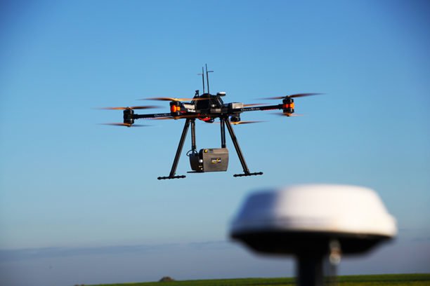
Boeing subsidiary Insitu has revealed that its latest advancements in High Accuracy Photogrammetry (HAP) are pushing the theoretical limits of aerial photography at altitude. Last month Insitu’s latest prototype carried a HAP payload that can capture images accurate to within five centimeters (cm) horizontally and 10cm vertically. Insitu describes this …
Read More »
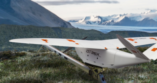
12:29 pm
BVLOS drones, Commercial Drones, Delair, Drone, drone photogrammetry, drones for surveying, Featured - Surveying, Fixed wing drones, industrial drones, LIDAR, mapping drones, News
Delair has been an trade chief for industrial drone options for a lot of years now – and as we speak they’ve introduced the following era of high-performance industrial drones with the Delair DT26X LiDAR UAV. It’s the primary fixed-wing to hold the subtle RIEGL LiDAR sensor. Founded in France, …
Read More »
12:02 pm
BlackSwift Technologies, Drone, Great Sand Dunes National Park, LIDAR, National Park Service, News, UAS Colorado, Wohnrade Civil Engineers
A rendering of the three dimensional data set obtained from the Great Sand Dunes mapping project. UAS Colorado, a non-profit business league committed to promoting and improving the commercial drone industry in Colorado, has announced that the first drone mapping project within a US National Park has been completed at …
Read More »
7:15 pm
Drone, Industries, inspection drones, LIDAR, News
LiDAR sensors and drones go together like PB&J and an industry report paints a rosy picture for both industries. “Global market intelligence company” Transparency Market Research released a study last week predicting an increase in the Light Detection and Ranging market as it relates to drone combos. Following the explosion …
Read More »