surveying drones

Terra Drone Aids Port Flooding Survey in Djibouti

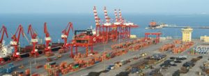
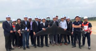
A key harbor in the African nation of Djibouti is safer from flooding threats thanks to Japanese drone provider Terra Drone Corporation. The company’s European division recently completed a five-day aerial survey of the Doraleh, one of Djibouti’s busiest ports. The high-resolution photogrammetric pavement assessment covered the city’s quay walls and …

Read More »

Terra Drone Elevates Presences in Global UAV Market

June is shaping up to take high flight for Japanese drone provider Terra Drone Corporation. Yesterday, the company’s European office announced an agreement to provide UAV services to the UK’s national mapping agency, Ordnance Survey. The contract includes services from orthomosaics to digital terrain models (DTM) and digital surface models. Terra …

Read More »

Phantom 4 RTK Launched Globally Today: DJI’s Ultimate Mappin…

DRONELIFE was present this morning when DJI announced the global launch of the Phantom 4 RTK mapping and survey drone.  The launch shows DJI’s continued commitment to the commercial market, where they already hold the major market share with the customer favorite Phantom 4, and the new Mavic Pro series. …

Read More »

Surveying with Drones: The Key Differences Between Aerial Li…

By Cargyrak (Own work) [CC BY-SA 4.0] The following is a guest post from Dustin Price, licensed land surveyor and operations manager at Landpoint: a surveying, aerial data and technical services provider. There has been an influx of new and, in some cases, game-changing surveying technologies that have popped up …

Read More »