7:29 pm
Drone, Drone News, Drone News Feeds, Featured - Surveying, News, Survey, Surveying
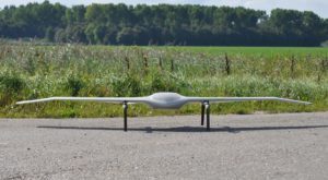
Event 38 and PLACE Partner to Map Turks and Caicos Islands Using E400 Drones by DRONELIFE Staff Writer Ian M. Crosby Mapping drone manufacturer Event 38 Unmanned Systems has announced the successful deployment of its E400 fixed-wing mapping drone for the collection of aerial imagery and mapping data in Turks …
Read More »
4:44 pm
Auterion Skynode, DeltaQuad, Drone, Drone News, Drone News Feeds, Dual Use, eco, eVTOL, Fixed wing drones, long endurance drones, News, Products, Survey, Surveying, VTOL
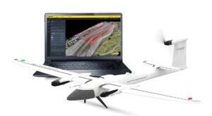
New eVTOL Fixed Wing from DeltaQuad Surpasses Limits of UAV Performance by DRONELIFE Staff Writer Ian M. Crosby Dutch drone manufacturer DeltaQuad has begun the public beta phase for its Evo model, a new Vertical Takeoff and Landing capable fixed wing electric UAV developed for mapping, inspection, and surveillance. Continue …
Read More »
12:24 pm
Drone, drone accelerator, Drone Industry, Drone News, Drone News Feeds, News, portable drones, Products, Selected - Agriculture, Surveying, Techstars, WingXpand
Startup WingXpand Selected to Join Techstars Accelerator Program by DRONELIFE Staff Writer Ian M. Crosby St. Louis based drone startup WingXpand has been chosen from a pool of over 600 international companies to join the world-renowned Techstars LA & Space Accelerator, a three-month program ending with a demo day for …
Read More »
6:45 pm
3d mapping, Applications, Drone, Drone News, Drone News Feeds, Drones in the News, F90+ Trinity drone, Featured - Surveying, mapping drone, News, Propeller Aero, Quantum-Systems, Surveying
Quantum-Systems Partners with Propeller Aero: Trinity F90+ Drone and Propeller Aero’s 3D Mapping Software by DRONELIFE Staff Writer Ian M Crosby Trimble [NASDAQ:TRMB] is one of the holdings in the AdvisorShares Drone Technology ETF [NYSE ARCA:UAV], the only ETF dedicated to the drone economy. The AdvisorShares Drone Technology ETF is …
Read More »
4:09 pm
BVLOS, BVLOS inspections, Drone, Drone Inspections, drone laws, Drone News, Drone News Feeds, FAA, Featured - FAA and Regulations, infrastructure inspection, News, Soaring Eagle, Surveying
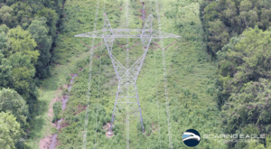
Soaring Eagle Technologies has received another FAA Certificate of Authorization. This BVLOS Waiver enables more efficient inspections. Soaring Eagle Technologies, is a leading drone data collection company working with critical infrastructure companies across the U.S. Having completed over 60 large scale BVLOS missions across the U.S under SGI (special government interest) waivers,the …
Read More »
11:40 am
data analytics, Drone, Drone News Feeds, News, Pix4D, Pix4D catch, Pix4D Mapper, Products, Surveying
viDoc RTK by Pix4D Launches in USA and Canada by DRONELIFE Staff Writer Ian M. Crosby Photogrammetry solutions leader Pix4D has just released the viDoc RTK rover in the USA and Canada. Previously released in Europe, the German-designed rover connects to the latest iOS devices in order to bring RTK …
Read More »
6:20 pm
aerial photographers, Drone, Drone News Feeds, drone surveying, Feature 1, first amendment rights, News, Surveying
Is drone mapping surveying without a license? A First Amendment lawsuit in North Carolina says surveyors cannot stop drone operators from selling photos and making maps. Hiring a surveyor is an expensive buisness, but necessary if you want to establish legal property lines. What if you just want to see …
Read More »
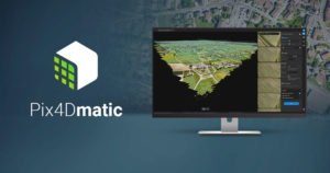
7:45 pm
commercial drone survey, corridor surveying, Drone, Drone News Feeds, drone surveying, Featured - Surveying, News, photogrammetry, Pix4D, Pix4Dmatic, Survey, Surveying
As mapping professionals are called on to map larger and larger areas around the world, photogrammetry software is evolving to meet their needs. Today, Pix4D announces PixDmatic: faster, accurate photogrammetry on a larger scale. “Projects that would have previously been mapped by aircraft are now being surveyed with drones,” says …
Read More »
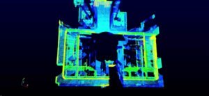
9:02 pm
DJI Airworks, DJI drone lidar, DJI industrial drones, DJI mapping drones, Drone, Drone News Feeds, News, Surveying
“LiDAR is an important piece to the puzzle of accurate models,” said Arjun Menon, DJI’s Engineering Manager, at this morning’s AirWorks keynote. “The challenges of LiDAR have always been in the category of production,” he notes – a highly functioning, lightweight and inexpensive LiDAR appropriate for drone use has been …
Read More »
7:57 pm
Colorado, Drone, Drone News, Drone News Feeds, Fixed wing, News, senseFly, survey drones, Surveying, Woolpert
File photo An architectural/engineering firm is using survey drones to make Colorado highways safer. Engineering firm Felsburg Holt & Ullevig brought in Woolpert to complete drone surveys for a right-of-way project in Castle Rock, Colo. Using a process known as InRoads Terrain Modeling Survey System, the Colorado Department of Transportation project …
Read More »