File photo
An architectural/engineering firm is using survey drones to make Colorado highways safer.
Engineering firm Felsburg Holt & Ullevig brought in Woolpert to complete drone surveys for a right-of-way project in Castle Rock, Colo. Using a process known as InRoads Terrain Modeling Survey System, the Colorado Department of Transportation project will use the imagery and mapping collected via survey drones to assess and design a frontage road adjacent to Interstate 25.
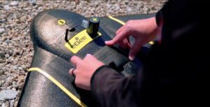
Woolpert uses survey drones provided by senseFly, a fixed-wing system that offers extended flight times and real-time kinematic (RTK) technology. “Paired with the Woolpert survey group’s ground control point data, [the drone] produces a highly accurate topographic base map and orthorectified imagery,” a Woolpert press release states.
For Woolpert, survey drones represent an innovative way to extend the company’s client base. So far, the firm has conducted drone projects for the FAA, U.S. defense department, airports and mining companies, as well as state DOT projects in Virginia, Pennsylvania, Florida and Ohio.
“This is a unique opportunity to introduce new technology to the town with a proven survey team,” Woolpert Project Manager Chris Raml said.
“Using UAS will save the client time and money, and offer a superior, visual deliverable. We know what’s required by the town of Castle Rock and CDOT, and our drones are collecting exactly what’s needed safely and efficiently.”
“Woolpert is leading the geospatial industry in UAS best practices and product quality assurances that meet and sometimes exceed the accuracies of traditional fixed-wing, frame-based cameras,” Woolpert Roads and Bridges Practice Leader Tom Ruschkewicz said.
In 2016, Michigan Tech Research Institute (MTRI) hired Woolpert to collect drone images and data on so-called haul roads – unpaved roads – throughout the Midwest.
The project, titled “Characterization of Unpaved Road Conditions Through the Use of Remote Sensing,” is sponsored by the U.S. Department of Transportation (USDOT). Researchers at Michigan Technological University use the data to test new algorithms for evaluating road conditions, similar to the technology used in precision agriculture to determine field conditions such as levels of drought and crop health based on aerial imagery.
Miriam McNabb contributed to this report.
Jason is a longstanding contributor to DroneLife with an avid interest in all things tech. He focuses on anti-drone technologies and the public safety sector; police, fire, and search and rescue.
Beginning his career as a journalist in 1996, Jason has since written and edited thousands of engaging news articles, blog posts, press releases and online content.
Email Jason
TWITTER:@JasonPReagan
Subscribe to DroneLife here.
https://dronelife.com/2020/05/29/woolpert-survey-drones/
 Unmanned Aerial Vehicle The latest drone news


