10:28 am
ANAFI USA, Drone, Drone News Feeds, Feature 1, News, Parrot Anafi Ai, Parrot drones, Pix4D, Skyward, Verizon
Parrot says consumers can expect the ANAFI Ai available in January by DRONELIFE Staff Writer Ian M. Crosby Leading European drone company Parrot has announced that the release of its ANAFI Ai model drone is on the horizon. The new drone will start shipping this coming January, with prices from …
Read More »
11:40 am
data analytics, Drone, Drone News Feeds, News, Pix4D, Pix4D catch, Pix4D Mapper, Products, Surveying
viDoc RTK by Pix4D Launches in USA and Canada by DRONELIFE Staff Writer Ian M. Crosby Photogrammetry solutions leader Pix4D has just released the viDoc RTK rover in the USA and Canada. Previously released in Europe, the German-designed rover connects to the latest iOS devices in order to bring RTK …
Read More »
7:55 pm
commercial drone software, Drone, drone mapping, drone mapping in Tokyo, Drone News Feeds, News, Pix4D
Photogrammetry platform provider Pix4D continues their global growth, expanding their Tokyo office to serve the Asia Pacific (APAC) region. The expansion demonstrates growing demand in the region for software solutions to support commercial drone operations. Swiss-based Pix4D, a Parrot company, already has offices in Lausanne, Berlin, Madrid, San Francisco, Denver, …
Read More »
10:33 pm
AUVSI, AUVSI NC, AUVSI North Carolina, Darshan Divakaran, Drone, Let's Talk Drones, News, Parrot, Pix4D, senseFly
Join AUVSI NC and DRONELIFE for the monthly Let’s Talk Drones open chatroom – your opportunity to ask anything and everything you want to know from AUVSI NC’s guests and panel of experts. This Friday, December 11 at 3 pm EST the Let’s Talk Drones Christmas Special will feature panelists …
Read More »
9:44 am
Autel, Cyber Monday, DJI, Drone, Drone News Feeds, Feature 1, News, Pix4D
There is still time to get deeply discounted hardware and software for your business. Check out these Cyber Monday drone deals and Pix4D‘s Cyber December offers! This year, the industry is embracing year end discounts: Cyber Monday drone deals are going well beyond recreational hardware (but that’s included, too.) If …
Read More »
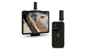
11:45 am
Drone, Drone News Feeds, ground images for photogrammetry, News, photogrammetry, Pix4D, Pix4dcatch
In a sign that the drone industry has reached a new phase in its evolution, drone companies are moving beyond drones. Photogrammetry solution provider Pix4D has launched Pix4Dcatch, a new app for getting ground images from iOS devices like iPads and iPhones. The new app means that operators can use …
Read More »
7:20 pm
ANAFI USA, Drone, drone manufacturers, drone mapping, Drone News Feeds, News, Parrot, Pix4D
Parrot, the leading European drone group, and Pix4D, the leading professional photogrammetry and drone mapping software company, “are excited to announce the latest generation ANAFI USA drone is now compatible with the Pix4D software suite,” says a Parrot press release. That’s not a surprise, as Parrot owns 95% of Pix4D. …
Read More »
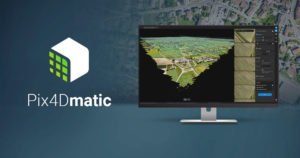
12:00 pm
Drone, Drone News Feeds, News, Pix4D, Pix4Dmapper, Pix4Dmatic, Products, VTOL, Wingtra, Wingtra Hub1.0
Wingtra‘s recent WingtraHub 1.0 release introduces a lean workflow between the WingtraOne drone and Pix4Dmatic, a “fresh Pix4D product for reliable speedy processing of large datasets,” says a Wingtra press release. “This integration is especially key since Wingtra’s VTOL drone is designed to map large sites fast and safely while …
Read More »
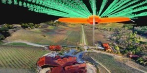
7:45 pm
commercial drone survey, corridor surveying, Drone, Drone News Feeds, drone surveying, Featured - Surveying, News, photogrammetry, Pix4D, Pix4Dmatic, Survey, Surveying
As mapping professionals are called on to map larger and larger areas around the world, photogrammetry software is evolving to meet their needs. Today, Pix4D announces PixDmatic: faster, accurate photogrammetry on a larger scale. “Projects that would have previously been mapped by aircraft are now being surveyed with drones,” says …
Read More »
5:14 pm
Autel, autel evo, Drone, drone for police, Drone News Feeds, drones for law enforcement, drones in public safety, fire drones, News, Pix4D, pix4d react, Police Drones
Last year at Commercial UAV Expo in Las Vegas, DRONELIFE got to see two amazing products at work. Demonstrated by the Las Vegas Police Department and Sundance Media Group, the Autel Evo II flew over a mock nighttime crime scene for evidence documentation: and Pix4Dreact, Pix4D’s real-time mapping solution for …
Read More »