1:59 pm
DL Exclusive, Drone, drone imaging, Drone News, Drone News Feeds, drones for agriculture, drones for conservation, Feature 1, Imaging, LIDAR, Lidar drone applications, News, Products, Quantum-Systems, Selected - Products, Sensors, Sony, wildlife international
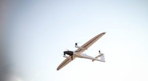
Drones equipped with high resolution lenses are a powerful tool in the fight to protect wildlife around the world. Here, Yasuo Baba of Sony Digital Imaging gives us the specifics of the project between Quantum-Systems and Wilderness International. The following is a guest post by Yasuo Baba, Director, Digital Imaging …
Read More »
6:31 pm
Alaska, climate change, Drone, Drone News, Drone News Feeds, Imaging, News, Surveying, Wingtra
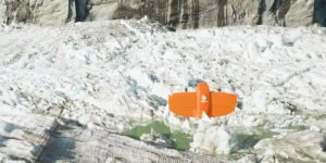
Source: WingtraOne Orthophoto survey drones are providing new insights to scientists tracking ice and water levels in Alaska. A research team led by Gabriel Wolken of the University of Alaska Fairbank’s Climate Adaptation Science Center has been measuring rising and falling ice and water levels in Suicide Basin glacial lake …
Read More »
3:55 pm
Andes drone research, Applications, Conservation, data analytics, Drone, Drone News, Drone News Feeds, DroneDeploy, Feature 1, flir, global warming studies with Drones, Imaging, News, Products, Sensors, Thermal Imaging
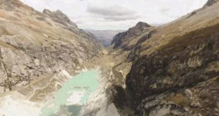
Researchers from Edinburgh University are using drones to study and demarcate global warming, and to determine how it is affecting glaciers in the Andes, a recent BBC article reports. DRONELIFE reached out to the makers of the drones to learn more about the project – but first, the research. Researches from …
Read More »
5:15 pm
Applications, Business and Finance, Conservation, Drone, drone images, Drone News, greening of the arctic, Imaging, News
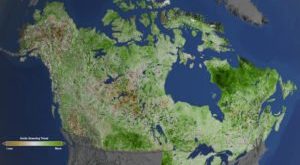
Credits: NASA’s Goddard Space Flight Center/Cindy Starr The Arctic is getting greener…and that is a very bad thing. Contrary to what you may have remembered from your grade school days, the Arctic is not the barren wasteland of ice that you may envision. The Arctic is a rich environment where …
Read More »
8:20 am
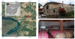
Drone, Drone News, Drone News Feeds, Imaging, News, Spain, wine
You may remember the late Orson Welles’ tagline from the 1970s Paul Masson commercials: “We will sell no wine before its time.” The sentiment makes compelling advertising copy but, as any vintner knows, the art of properly ageing wine can’t be bottled in a snappy catchphrase. Beyond soil quality and …
Read More »
10:47 pm
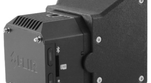
Drone, Drone News, Drone News Feeds, FLIR Systems, Imaging, News, TeAx, Thermal Imaging
We talk about how cool drones are all the time…right? But did you ever think about the technology that hangs under a drone — hardware that delivers awesome data and superior telemetry? German thermal-imaging company TeAx Technology is one of many such companies that often perform the unsung “heavy lifting” when …
Read More »
9:31 am
Business and Finance, commercial drone software., DJI, dji terra, Drone, drone data, Featured, Featured - Business, Imaging, modeling, Surveying
Not that many years ago, DJI was credited with forcing several competitors to pivot out of the drone hardware market and into commercial software. The Chinese company’s drones were too good and too cheap for the likes of 3DR to compete with. Now the world’s leading manufacturer has launched Terra, …
Read More »
3:36 am
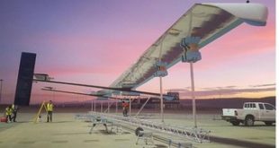
Aerospace, astigan, Business and Finance, Drone, Drone News Feeds, Enthusiasts, Fixed wing, HAPS, Imaging, mapping, News, ordnance survey, solar power, Technology, UK
National mapping agency for Great Britain and leading geospatial data organization Ordnance Survey (OS) has announced plans to launch a solar-powered drone that will fly at high altitude to complement existing satellite mapping systems. The aim of the High Altitude Psuedo Satellite (HAPS) project, called Astigan, is to provide faster, higher quality images …
Read More »
11:32 am
3d mapping, agriculture drone, Applications, Drone, drone cameras, drone surveying, Featured - Agriculture, Featured - Products, Featured - Surveying, Imaging, jeff Fagerman, lidarausa.com, Mining, Mining and Construction, philippe simard, SimActive
SimActive Inc., recently announces the expansion of its network of resellers for medium format licenses. The new strategic alliances allow them to address the growing market need for processing imagery from medium format sensors. Partners include firms such as LiDARUSA, who offers SimActive’s Correlator3D™ to complement Phase One cameras. This …
Read More »
3:36 am
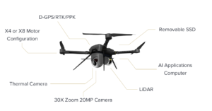
Apollo Robotics, Drone, Drone News, Drone News Feeds, Imaging, Inspection, News
Autonomous drone company Apollo Robotics is launching an early-bird program allowing professional drone industry players to pre-order new products. The Ventura, Calif.-based firm has launched the Apollo Development Partner Program which will give early access to fully automated, autonomous surveying drone platforms to qualified professionals. The Apollo system combines multi-sensor …
Read More »