5:07 pm
data, data privacy, drone data, drone data management, drone data protection, Drone Tech, Drone Technology, robotics, Uav
Data Security and Privacy at Autel Robotics In an era defined by advanced technology and connected devices, concerns around data security and user privacy have become increasingly important. Autel Robotics recognises these concerns and has implemented comprehensive technical and organisational measures to protect user data across its drones, software, and …
Read More »
8:51 pm
Drone, drone data, drone data security, Drone News, Drone News Feeds, News, Skydio, US Drone manufacturers
Skydio Announces SOC 2 Type II Compliance by DRONELIFE Staff Writer Ian M. Crosby Earlier this week, Skydio announced a major inclusion to its data security compliance in the form of a SOC 2 (System and Organization Controls) Type II report, an internal audit that provides insight into the way …
Read More »
8:58 pm
automated inspections, data analytics, Digital Twins, DL Exclusive, Drone, drone data, Drone News, Drone News Feeds, Feature 1, News, Optelos, Products
Beyond Drone Data: Optelos on How Digital Twins and Immersive Data Visualizations are Transforming Business Optelos is a respected name in the drone industry: but drones have never been their only focus. The company understood “it’s not the drone, it’s the data,” long before that phrase became a theme in …
Read More »
1:52 pm
Drone, drone data, drone images, Drone Industry, Drone News Feeds, drone pictures, Globe, GLOBHE, News
Copyright image of Antarctica used with express permission of GLOBHE. The GLOBHE world record for largest album of drone-collected images was achieved by “crowd-droning.” Here’s how the concept can be used to help save the planet. *Copyright images used with express permission from GLOBHE. By Jim Magill GLOBHE, a Stockholm …
Read More »
11:50 pm
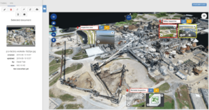
Digital Twins, Drone, drone data, Drone News Feeds, News, Optelos, SKYCAM, visual data management
Optelos delivers robust data management and analytics: SkyCam Aviation offers unique multi-spectral data collection services. Together, SkyCam and Optelos offer clients the actionable insights they need. Unique Data Collection: Unique Data Management “SkyCam Aviation provides visual data collection services using fixed wing aircraft and employs multi sensor technology to provide …
Read More »
5:19 pm
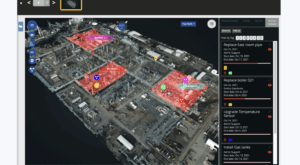
ai powered inspections, data management, data managements, Drone, drone data, Drone Inspections, Drone News Feeds, Inspection, News, Optelos, Sponsored Content
Saving Time, Reducing Risk: Using Digital Twins to Optimize Turnarounds Enterprise companies are inundated with digital data: from aerial images to ground-based walkthroughs, companies have more information available to them than ever before. But is all of this data helping the bottom line? At the Energy Drone and Robotics Summit …
Read More »
10:44 am
Drone, drone data, Drone Inspections, Drone News Feeds, Dual Sensor, Enthusiasts, Media, News, Visual Intelligence
Visual Intelligence provides patented dual sensor technology combined with software and analytics to deliver millimeter-class drone data. Now, through a new partnership, inspection specialists ARE will deliver rail and utility engineering services based on the newly enabled solution. There is no doubt that drone technology has become an important tool for …
Read More »
6:38 pm
Drone, drone data, drone LiDAR, drone mapping, Drone News Feeds, drone photogrammetry, LIDAR, News, photogrammetry, SimActive
Drone-based mapping and LiDAR are a powerful combination. Now, Canada’s SimActive Inc., a leading developer of photogrammetry software that can accommodate aerial imagery from satellite, manned aircraft, or drones, announces the integration of its Correlator3D™ product into LiDAR systems for drones developed by LiDAR USA. LiDARUSA, also known as Fagerman Technologies, …
Read More »
10:34 pm
data privacy, DJI, Drone, drone data, drone data security, Drone News Feeds, Featured - Products, local data mode, News, Safety and Security
Amid ongoing trade tensions between China and the U.S. that has led to concerns about data privacy for DJI drones, DJI continues to enhance the security of their platform. Today, DJI announced that they would make Local Data Mode – a feature that eliminates entirely the need for internet connectivity, completely …
Read More »
8:13 pm
Air Force 1, Drone, drone data, drone incidents, drone near Air Force 1, Drone News Feeds, drones near airplanes, News
U.S. Air Force photo by Airman 1st Class Brandon Esau News and Commentary. Was there a drone near Air Force 1 as President Trump flew into Andrews Air Force Base? If so, there’s a problem for the drone industry. And if not, there’s a problem for the drone industry. Last week, …
Read More »