Visual Intelligence provides patented dual sensor technology combined with software and analytics to deliver millimeter-class drone data. Now, through a new partnership, inspection specialists ARE will deliver rail and utility engineering services based on the newly enabled solution.
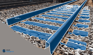
There is no doubt that drone technology has become an important tool for infrastructure inspections. For engineering use cases, however, a new level of drone data accuracy is required. That’s the goal of Visual Intelligence’s solution: a combination of dual sensor technology, collection management software, and a powerful analytics engine. According to a recent press release:
Visual Intelligence is the first unified drone platform capable of digitizing physical infrastructure with millimeter accuracy. With data that is 10-20 times more accurate than mobile Lidar technologies and 50-100 times more accurate than single camera commercial drones, this new class of drone data opens the door to an unexplored category of offerings that serve engineering workflows and benefit analysis across an asset’s complete lifecycle.
The new partnership will bring the Visual Intelligence solution into the field. “Visual Intelligence will work with ARE to capture engineering-grade datasets on infrastructure including railways, bridges and utilities to better analyze structures and provide unprecedented services to customers,” says the press release.
“ARE’s knowledge of infrastructure lifecycles, its proven engineering expertise, and its progressive approaches to solving customer challenges is a natural fit for our technology in the rail and utility industries,” said Ted Miller, Founder of Visual Intelligence and former Chairman, CEO of Crown Castle International (NYSE: CCI). “Currently delivering UAS solutions in 27 states across the US, this partnership will bring the value of millimeter- class data to rail and bridge engineering analysis across the country.”
ARE will become part of the Visual Intelligence provider ecosystem, a worldwide network of partnerships that offers proprietary access to sensors and software to help partners achieve engineering-grade accuracy from drone captures, enabling new forms of automation, maintenance efficiencies and engineering analysis.
“We believe this new class of drone data will address an underserved, but foundational part of infrastructure management – the engineering department,” said Dave Anderson, PE, CEO at ARE. “With engineering-grade accuracy, we’ll unlock the full potential of digital twins, artificial intelligence and inspection automation, placing our customers on a path for success in the new digital infrastructure era.”
https://dronelife.com/2021/02/26/dual-sensor-technology-visual-intelligence-and-are-partner-to-deliver-millimeter-class-drone-data/


