Canadian mapping platform SimActive has added some significant new capabilities this year, including colorized point clouds and reflective calibration. CEO Philippe Simard explains what these features are – and how clients are using them.
SimActive releases new features regularly. “With our user base growing exponentially, we are constantly monitoring how our software is being used and how it can be further improved,” says Simard. “Customer feedback is central in shaping our product development.”
The latest versions of SimActive’s mapping software – which accommodates images from satellite, manned aircraft, and drones – have included several new capabilities. Calibrated reflectance maps can now be generated from multispectral imagery using reflectance panels and sun sensors. LiDAR data can now be merged with imagery, an efficient method of producing colorized point clouds: assigning color information to each 3D point captured by the LiDAR sensor.
Reflectance Calibration: Assessing Vegetation Health in Precision Agriculture
Reflectance is the amount of light that is reflected from surfaces (and captured by a multispectral sensor) relative to incoming light, Simard explains. “To calculate the incoming light precisely, one option is to evaluate how much light is being radiated by using sun sensors. Another way is to use calibration panels for which the reflectance is known and use them as a reference to calculate reflectance for other surfaces,” he says.
For drone service providers working in agriculture, this is significant feature. Reflectance maps are often used in agriculture to assess vegetation health; allowing early detection of abnormal changes in the growth process. “They can also help in locating stressed plants, in measuring crop productivity and in predicting future yield,” Simard explains.

Merging LiDAR with Imagery for Colorized Point Clouds
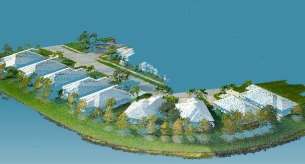
LiDAR data provide highly dense point clouds. When combined with imagery, these point clouds are a rich source of information – one used heavily by large enterprise. “One interesting application is corridor mapping for powerline inspection,” Simard says. “Data can be collected frequently and used to monitor vegetation encroachment – which reallly minimizes the risks of power failures.”
SimActive’s new capabilities in merging LiDAR data with imagery represents a major improvement in generating colorized point clouds. “The main challenge when combining 3D points with images is to perfectly align both datasets together,” Simard says. Typically, this is achieved by manually tagging ground control points: but with its latest software version, SimActive has introduced a significantly more efficient method. “The LiDAR data is directly used as a reference, and the imagery is automatically registered through bundle adjustment,” Simard explains.
What’s Next?
With the focus on responding to customer needs, Simard says SimActive is preparing for industry growth. “We are anticipating the future needs of the industry – and we see growing requirements for processing larger projects,” he says. “Our focus is to stay ahead of competition and keep increasing processing speeds to handle large-scale production needs.”
Miriam McNabb is the Editor-in-Chief of DRONELIFE and CEO of JobForDrones, a professional drone services marketplace, and a fascinated observer of the emerging drone industry and the regulatory environment for drones. Miriam has penned over 3,000 articles focused on the commercial drone space and is an international speaker and recognized figure in the industry. Miriam has a degree from the University of Chicago and over 20 years of experience in high tech sales and marketing for new technologies.
For drone industry consulting or writing, Email Miriam.
TWITTER:@spaldingbarker
Subscribe to DroneLife here.
https://dronelife.com/2021/02/18/creating-colorized-point-clouds-reflective-calibration-and-more-diving-into-simactives-new-features/


