Drone Mapping of UNESCO Archaeological Site: From Simactive
Drones mapping of UNESCO Archaeological sites are helping to gather the necessary data to help prepare orthophoto maps and digital elevation models of valuable areas. The drone mapping company SimActive recently announced that it is involved in the mapping of a UNESCO Archaeological site of Halin in Myanmar. This is located in the country of Burma.
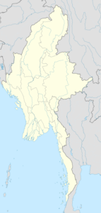
Drone Mapping of UNESCO Archaeological Site: CC BY-SA 3.0
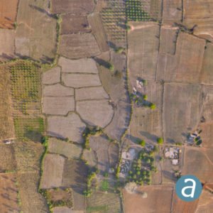
The goal of the drone imagery and data analysis is to find new features that had been previously overlooked, as well as to assess the state of the known ones over time. These include
monumental walls, dams and digging canals: many of which are still visible in the landscape.
The resulting geospatial data captured by drone checks to ensure that modern constructions or farming are not causing damage to the ancient structures.
“Our collaboration with SimActive is allowing us to produce highly accurate maps of an
historic site that is more than 2,000 years old,” said Kasper Hanus, research fellow at The
Institute of Mediterranean and Oriental Cultures of the Polish Academy of Sciences. “The
datasets help us understand the past civilizations and safeguard the common heritage of
mankind.”
Aerial data has become a key tool for archeologists. As drones provide a more affordable and accessible way to provide that data, more accurate maps are being produced of ancient sites. This data provides government agencies and researchers with a common understanding of the site, so that they can be better preserved.
CEO DroneLife.com, DroneRacingLife.com, and CMO of Jobfordrones.com. Principle at Spalding Barker Strategies. Proud father of two. Enjoys karate, Sherlock Holmes, and interesting things. Subscribe to all things drone at DroneLife here. Email is [email protected] Make Sure that you WhiteList us in your email to make sure you get our Newsletter. [email protected]
https://dronelife.com/2020/04/28/drone-mapping-of-unesco-archaeological-site/


