12:23 am
correlator3d, Drone, drone mapping, Drone News, Drone News Feeds, News, Phase One IIQ, SimActive
SimActive and Phase One IIQ Announce Integration in Correlator 3D Version 9.2 SimActive Inc.’s Correlator 3D photogrammetry software is designed for large mapping projects. Phase One, a pioneer of digital imaging sensors and airborne systems, are a leading tool for data capture. Now, SimActive and Phase One have partnered on …
Read More »
7:47 pm
correlator3d, Drone, drone mapping, Drone News Feeds, photogrammetry, SimActive
SimActive‘s new version of Correlator 3D, version 8.6, is feature-rich – making mapping from aerial images easier and more accurate all the time. Canada’s SimActive is a photogrammetry software that began as a solution for aerial images from satellite and manned aircraft. The inclusion of drone data in the solution …
Read More »
10:02 am
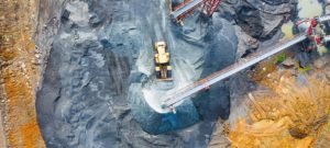
Applications, correlator3d, Drone, Drone News, Drones in the News, Featured - Business, Featured - Mining, Featured - Surveying, Mining, Mining and Aggregates, Mining and Construction, News, orthomosaics, photogrammetry, SimActive
From Simactive Canadian mapping software company SimActive has added additional capacity to be able to automatically assess multiple volumes of material (aggregates and other material) for projects and to report based upon the findings. If the same area is being flown, users can then compare the volumes and access differences …
Read More »
1:01 pm
correlator3d, Drone, drone mapping, Products, SimActive, Sponsored Content
SimActive Further Accelerates Processing with New Version 8.4 Montreal, Canada, January 14th, 2020 – SimActive Inc., a world-leading developer of photogrammetry software, announces the release of Correlator3D™ version 8.4 with significant accelerations. The new version leads to speeds that are multiple times faster compared to previous releases. Correlator3D™ 8.4 allows …
Read More »
2:48 am
Applications, Business and Finance, correlator3d, Drone, Drone News, Featured - Surveying, SimActive
It’s a truism that data is king in the drone industry. Getting good quality, actionable drone data without being an expert in image processing and photogrammetry – the science of accurate measurement from images – is a challenge for many companies. Now, Canadian data processing provider SimActive is offering full …
Read More »