6:15 pm
DL Exclusive, Drone, drone mapping, Drone News Feeds, drones for forestry, drones in agriculture, drones in mining, Feature 1, LiDAR for drones, multispectral imaging, News, philippe simard, SimActive
image courtesy SimActive Philippe Simard, of Canada’s SimActive mapping software, started out working directly with large mapping companies – or the military. With the growth of the drone industry, however, things have changed. “We used to only work with very highly qualified firms investing millions of dollars in planes – …
Read More »
10:02 am
Applications, correlator3d, Drone, Drone News, Drones in the News, Featured - Business, Featured - Mining, Featured - Surveying, Mining, Mining and Aggregates, Mining and Construction, News, orthomosaics, photogrammetry, SimActive
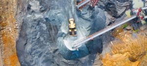
From Simactive Canadian mapping software company SimActive has added additional capacity to be able to automatically assess multiple volumes of material (aggregates and other material) for projects and to report based upon the findings. If the same area is being flown, users can then compare the volumes and access differences …
Read More »
1:01 pm
correlator3d, Drone, drone mapping, Products, SimActive, Sponsored Content
SimActive Further Accelerates Processing with New Version 8.4 Montreal, Canada, January 14th, 2020 – SimActive Inc., a world-leading developer of photogrammetry software, announces the release of Correlator3D™ version 8.4 with significant accelerations. The new version leads to speeds that are multiple times faster compared to previous releases. Correlator3D™ 8.4 allows …
Read More »
12:44 pm
Aerospace, Agriculture, Applications, Auto, Business and Finance, Chemical, Construction, Defense, Delivery, Drone, Drone News, Education, Entertainment, Healthcare, Insurance, LIDAR, Mining and Aggregates, News, SimActive
SimActive has just announced some additional functionality removes some of the manual processes currently needed to process softificated imagery. From their press release below: “Removing the need to manually tag GCPs facilitates the integration of LiDAR data with imagery”, said Dr Philippe Simard, President of SimActive. “Our clients can benefit …
Read More »
2:48 am
Applications, Business and Finance, correlator3d, Drone, Drone News, Featured - Surveying, SimActive
It’s a truism that data is king in the drone industry. Getting good quality, actionable drone data without being an expert in image processing and photogrammetry – the science of accurate measurement from images – is a challenge for many companies. Now, Canadian data processing provider SimActive is offering full …
Read More »
4:33 pm
Correlator 3D, Drone, mica sense, multispectral imaging, News, SimActive
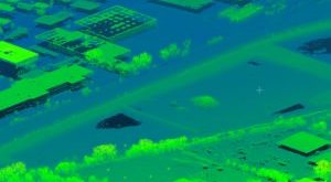
Image from MicaSense RedEdge USGS Unmanned Aircraft Systems [CC BY 2.0] Data gathered from sophisticated sensors requires sophisticated processing. Now, SimActive Inc., a leading developer of photogrammetry software, has announces the release of Correlator3D™ version 8.2 – which provides advanced processing capabilities of multispectral imagery. Correlator3D’s new version registers multispectral as well …
Read More »
2:22 pm
Correlator 3D, Drone, SimActive, Uncategorized, Wingtra
When it comes to enterprise drone applications, it’s all about the data – and the drone. Swiss provider Wingtra, a leading provider of VTOL hybrid drones for industry, has partnered with SimActive, the makers of Correlator 3D software, to offer customers rapid processing of high accuracy maps and survey data. …
Read More »
8:48 am
AUVSI, Drone, DroneDeploy, Feature 1, flir, News, Optelos, ParaZero, SimActive, Startup Showdown, women in drones, Xcellence Awards
julie corsi from Palos Heights, IL, USA [CC BY 2.0 ] If you’re headed to AUVSI’s Xponential in Chicago today, get ready for a huge show of all things unmanned. Xponential is one of the biggest shows in the industry, with so much to see and hear that attendees are spoiled …
Read More »
2:50 pm
Drone, eBee, News, senseFly, SimActive
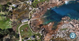
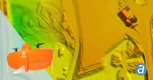
image courtesy SimActive Three drone industry leaders have joined forces for shoreline mapping on France’s Pink Granite Coast as part of a conservation project. Altimedias, a drone data collection and processing firm, is using the senseFly eBee combined with mapping software SimActive to create 3D textured models of the sensational …
Read More »
11:47 pm
Drone, drone mapping, drone mapping applications, News, SimActive
As the industry progresses, drone mapping tools are getting more and more sophisticated. Canadian mapping software company SimActive has traditionally been a leader in mapping for images from satellite and airplane; now they’ve added drone images to their offering. The latest version offers advanced editing tools to perfect the product …
Read More »