image courtesy SimActive
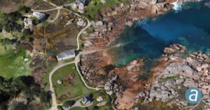
Three drone industry leaders have joined forces for shoreline mapping on France’s Pink Granite Coast as part of a conservation project. Altimedias, a drone data collection and processing firm, is using the senseFly eBee combined with mapping software SimActive to create 3D textured models of the sensational coastline in northern Brittany.
Registration data in the U.S. has recently confirmed that senseFly’s eBee is the most widely used fixed-wing UAV in the United States. Canadian software company SimActive is a leading mapping software provider, able to process data from sources that range from satellites to drones. The Altimedias CEO says that combination of tools was ideal for the project.
The following is a SimActive press release.
Montreal, Canada, April 9th, 2019– SimActive Inc., a world-leading developer of photogrammetry software, announces that Correlator3D™ is being used for mapping projects in Brittany, France by Altimedias. An eBee X equipped with senseFly S.O.D.A. 3D camera is flown along the shoreline to produce high-resolution true orthomosaics and 3D models.
“The quality of outputs from Correlator3D™ is exceptional and the mosaic renders the vivid colours of the Pink Granite Coast,” said Didier Wasselin, COO at Altimedias. “Such results are very useful for heritage conservation and decision making by local authorities.”
“The combination of SimActive software and senseFly eBee Plus X is an ideal combination, due to the accurate RTK / PPK and optimized aerial triangulation”, said Francois Gervaix, Technical Advisor at SimActive. “The S.O.D.A. oblique imagery leads to outstanding 3D textured models.”
About Altimedias
Based in France, Altimedias is a leading firm specialized in drone data collection and processing. Services offered include building facades and roof inspection, topological surveys, photogrammetric production and drone training. For more information, visit www.altimedias.fr
About SimActive
SimActive is the developer of Correlator3D™ software, a patented end-to-end photogrammetry solution for the generation of high-quality geospatial data from satellite and aerial imagery, including UAVs. Correlator3D™ performs aerial triangulation (AT) and produces dense digital surface models (DSM), digital terrain models (DTM), point clouds, orthomosaics, 3D models and vectorized 3D features. Powered by GPU technology and multi-core CPUs, Correlator3D™ ensures matchless processing speed to support rapid production of large datasets. SimActive has been selling Correlator3D™ to leading mapping firms and government organizations around the world, offering cutting-edge photogrammetry software backed by exceptional customer support. For more information, visit www.simactive.com.
Miriam McNabb is the Editor-in-Chief of DRONELIFE and CEO of JobForDrones, a professional drone services marketplace, and a fascinated observer of the emerging drone industry and the regulatory environment for drones. Miriam has a degree from the University of Chicago and over 20 years of experience in high tech sales and marketing for new technologies.
Email Miriam
TWITTER:@spaldingbarker
Subscribe to DroneLife here.
https://dronelife.com/2019/04/09/shoreline-mapping-with-ebee-x-and-simactives-correlator-3d/


