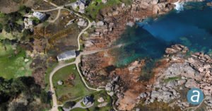
image courtesy SimActive Philippe Simard, of Canada’s SimActive mapping software, started out working directly with large mapping companies – or the military. With the growth of the drone industry, however, things have changed. “We used to only work with very highly qualified firms investing millions of dollars in planes – …
Read More »Multispectral Imaging Processing Expands Drone Applications …
Image from MicaSense RedEdge USGS Unmanned Aircraft Systems [CC BY 2.0] Data gathered from sophisticated sensors requires sophisticated processing. Now, SimActive Inc., a leading developer of photogrammetry software, has announces the release of Correlator3D™ version 8.2 – which provides advanced processing capabilities of multispectral imagery. Correlator3D’s new version registers multispectral as well …
Read More »