image courtesy SimActive
Canada-based SimActive isn’t just a drone company. But as one of the global leaders in photogrammetry, SimActive sees drones as a key element in democratizing mapping data.
In 2003, when Philippe Simard and his younger brother Louis started SimActive, the Canadian army was engaged in Afghanistan, mapping the country to support the U.S. troops. “The photogrammetry software at the time was very complicated and required a lot of training – they were having to continue to train all of the time, as personnel moved in and out of the job,” explains Philippe Simard. “SimActive won a major contract to make that work more smoothly, more quickly – it was a mission critical situation.”

Philippe Simard, PhD and Louis Simard, M. Eng image courtesy SimActive
Philippe Simard holds a PhD in computer vision and AI, his brother Louis Simard holds a Masters of Engineering in the same subject. The two developed a revolutionary solution: an easy to use software that processed satellite data with both speed and precision. In 2008, they added large format camera capability to the solution – and in 2013, they opened the platform to drone cameras. Simard explains that customers of all sizes use drone data. “We have a lot of government clients that have airplanes – but they want to use drones for smaller projects, because they offer a quicker turnaround,” Simard explains. “Large enterprise and government want to choose their tools: country-wide projects are done with satellite, city-wide projects use airplanes, and smaller projects use drones.” It’s an impressive offering, and one that strikes a chord with many drone stakeholders – Correlator 3D processes data up to 20X faster than other providers, without sacrificing accuracy.
Getting into the Drone Business
While drones have made a big impact on the mapping industry, Simard says that the growth curve hasn’t always been steady.
“Everybody saw drones as this tool that would revolutionize mapping, but nobody really thought through the business case,” Simard explains. “Three or four years ago there was a huge influx of new drone companies providing drone solutions – now that many of those companies have gone, but those that remain are more serious.
Is it growing as fast as everyone thought it would? No. Is it growing? Yes,” Simard says. “Now, people are realizing that drones have allowed a democratization of mapping. That’s helped to promote mapping.”

image courtesy SimActive
Now that drone technology has reached some level of maturity, Simard explains, the data – and companies like SimActive – are more important. “All of the hardware components are good – anyone who wants to collect good data can do it,” he says. “The challenge is what to do with the all of the raw data – customers need better processing technologies, and easier conversion of raw data into usable products.”
What Comes Next?
With clients that range from governments to individual drone operators, Simard has a unique perspective on industry trends. While artificial intelligence (AI) is a major catchphrase these days, Simard says that for large enterprise customers the jury is still out. “The problem with AI is that there is a still a big question mark,” he says. “AI may be correct 95% of the time – but it’s very, very expensive to do the last 5% manually.”
What’s next for SimActive? “We’ve spent the last 5 years adding functionality to make it easy for people without photogrammetry and mapping degrees to use the product,” says Simard. “In the next years, we’re re-centering ourselves with larger enterprise clients that need major functionality.”
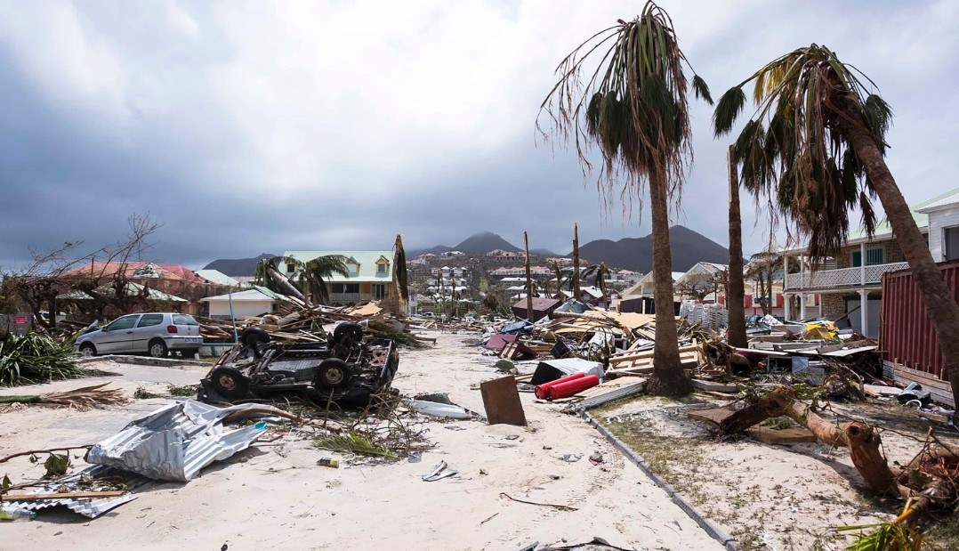
image courtesy SimActive
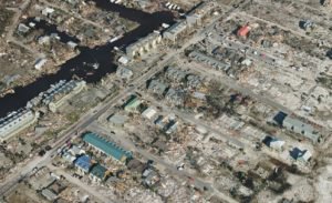
In addition to serving clients in more than 100 countries around the world, SimActive has taken their place in the drone community by supporting mapping efforts for people in need. From St. Martin in the Caribbean to Mexico Beach in Florida, SimActive has supported disaster relief efforts as a critical partner.
“We want to help people benefit from all of the geospatial technologies available,” says Simard.
Miriam McNabb is the Editor-in-Chief of DRONELIFE and CEO of JobForDrones, a professional drone services marketplace, and a fascinated observer of the emerging drone industry and the regulatory environment for drones. Miriam has a degree from the University of Chicago and over 20 years of experience in high tech sales and marketing for new technologies.
Email Miriam
TWITTER:@spaldingbarker
Subscribe to DroneLife here.
https://dronelife.com/2019/02/28/dronelife-exclusive-simactive-and-the-democratization-of-mapping-with-drones/


