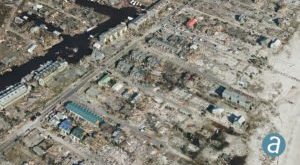
Disaster response efforts following Hurricane Michael have showcased high precision drone geospatial data. SimActive, a world-leading developer of photogrammetry software, partnered with drone service provider Midwest Aerial to perform critical damage assessment of homes and infrastructure after Hurricane Michael struck the Gulf Coast last month. Hurricane Michael destroyed billions of …
Read More »What Exactly Can Drone Geospatial Data Do? Disaster Response…