12:33 pm
Applications, Drone, Featured - Products, Featured - Surveying, Gremsy, gremsy gimbles, gremsy t3, Inspection, Media, Sponsored Content, T3
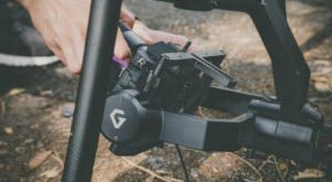
The Gremsy T3V3: HDMI quick release, stronger motor, and more. Vietnam-based Gremsy, manufacturers of quality gimbals for the professional market, announce their latest gimbal version today. Designed for widespread use, the Gremsy T3 is already one of the most popular gimbals used in inspections, mapping, and other commercial applications. It …
Read More »
11:27 pm
Applications, Down to Earth, Drone, drone surveying, Featured - Surveying, Microdrones, Microdrones GmbH, Mining and Aggregates, Mining and Construction, Real Estate
We here at DRONELIFE are as vulnerable as anyone else to the joys of reality TV, so we were pleased to see that drone provider Microdrones is scheduled to release a reality TV styled video webinar series named Down to Earth. The idea is to show the challenges and hazards that surveying …
Read More »
2:48 am
Applications, Business and Finance, correlator3d, Drone, Drone News, Featured - Surveying, SimActive
It’s a truism that data is king in the drone industry. Getting good quality, actionable drone data without being an expert in image processing and photogrammetry – the science of accurate measurement from images – is a challenge for many companies. Now, Canadian data processing provider SimActive is offering full …
Read More »
12:59 am
Business and Finance, Drone, Drone News Feeds, ebee x, Featured - Surveying, Fixed wing, Inspections, News, Parrot, Products, Raptor Maps, senseFly, solar 360, Solar farms, solar inspections, Technology, Thermal Imaging
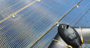
senseFly has launched a new drone at AUVSI XPONENTIAL 2019, the Solar 360. The fixed-wing thermal drone solution has been designed specifically for solar farm inspections. The senseFly Solar 360 has been developed in collaboration with software company Raptor Maps and promises to enable an automated assessment of solar plant …
Read More »
12:23 pm
Drone, Drone News Feeds, drones in energy, Dustin Price, Feature 1, Featured - Surveying, Landpoint, News, Surveying
Drones are significant tools in pipeline surveys – get an professional surveyor’s insider look at why, and how to optimize the ROI. The following is a guest post by Dustin Price, a licensed land surveyor and the Operations Manager at Landpoint. For pipeline surveys, there’s a lot that needs to be …
Read More »
6:16 pm
Drone, Drone News Feeds, Drones for Construction, Feature 1, Featured - Surveying, LIDAR, News, Products, Ryan LaDue, Sensors
Avalanche photodiode sensors. If you don’t know what they are – you need to. The following is a guest post by talented author and self-described nerd Ryan LaDue. The Latest Wave of Sensor Tech Could be a Game-Changer for LiDAR-Equipped UAVs Avalanche photodiode sensors are semiconductors capable of converting photons …
Read More »
8:10 pm
Agriculture, Applications, Commerccial drone, Construction, Drone, Drone News, dronelife exclusive, Feature 1, Featured - Surveying, Mining, Mining and Aggregates, Mining and Construction, News, Surveying, terra drone india, UTM
DRONELIFE recently caught up with Prateek Srivastava, CEO of Terra Drone India. As India becomes a major player in the global drone industry, Srivastava gives his take on the commercial drone industry, unmanned traffic management (UTM), and where he sees the commercial market going in India. DRONELIFE: Can you tell our …
Read More »
11:32 am
3d mapping, agriculture drone, Applications, Drone, drone cameras, drone surveying, Featured - Agriculture, Featured - Products, Featured - Surveying, Imaging, jeff Fagerman, lidarausa.com, Mining, Mining and Construction, philippe simard, SimActive
SimActive Inc., recently announces the expansion of its network of resellers for medium format licenses. The new strategic alliances allow them to address the growing market need for processing imagery from medium format sensors. Partners include firms such as LiDARUSA, who offers SimActive’s Correlator3D™ to complement Phase One cameras. This …
Read More »
6:24 pm
Business and Finance, Drone, Drone News Feeds, Featured - Surveying, H520 drone, Mining and Aggregates, News, Products, Real Time Kinematic, rtk, Technology, Yuneec
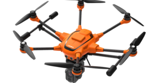
Drone manufacturer Yuneec has announced that its commercial hexacopter, the H520, will now be optionally available with an RTK (Real Time Kinematic) system. The addition of the RTK system from Swiss company Fixposition, means that even under difficult GPS conditions – in dense urban areas or canyons, for example – …
Read More »
1:06 am
AI, charity, Conservation, DJI, Drone, Drone News Feeds, Drones in the News, England, Enthusiasts, Featured, Featured - Surveying, machine learning, News, peter kohler, plastic waste, pollution, Technology, the plastic tide
An environmental group in England is utilizing drones and synthetic intelligence to assist measure plastic waste on the world’s seashores. In the final 10 years, there was a 250% enhance of plastics washing up on the world’s seashores. Of the tens of millions of tons which might be dumped in …
Read More »