senseFly has launched a new drone at AUVSI XPONENTIAL 2019, the Solar 360. The fixed-wing thermal drone solution has been designed specifically for solar farm inspections.
The senseFly Solar 360 has been developed in collaboration with software company Raptor Maps and promises to enable an automated assessment of solar plant performance at a sub-module level.
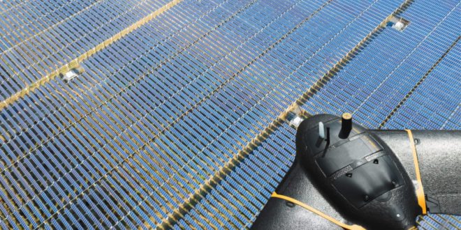
The Solar 360 is a solution that combines the eBee X fixed-wing drone, senseFly’s Duet T thermal mapping camera, and Raptor Maps’ solar-specific software. senseFly says the package can be “easily integrated into solar management workflows without requiring either drone piloting skills or the manual analysis of aerial solar farm data.”
“At senseFly we are continually looking across the industry to identify new commercial partners with whom we can bring to market what our customers need, which is vertically-focused end-to-end solutions,” said Gilles Labossière, CEO of senseFly.
“With Raptor Maps, we are collaborating with a true solar industry pioneer. Their software takes the guesswork out of solar farm inspection and, crucially, speeds up this process – from days down to hours. This efficiency, combined with the eBee X’s large coverage and reliability, ensures that farm owners and operators — or the drone service providers they employ — can inspect utility-scale solar farms more quickly, easily, and accurately than ever before.”
Read more: Parrot Adds To Enterprise Solutions With ANAFI Thermal
Tapping into the emerging solar market
“Solar power is the largest source of new energy generation in the world,” said Nikhil Vadhavkar, CEO of Raptor Maps.
“This rapid growth has fueled demand for industry-specific solutions to allow solar customers to scale. Our enterprise-grade software has been deployed across six continents and 25 million solar panels to increase power production and reduce risk and maintenance cost across solar portfolios. We are proud to collaborate with senseFly, the industry leaders in commercial fixed-wing drones, to increase access to Raptor Maps while providing a comprehensive, end-to-end solution that scales with the solar industry.”
A closer look at the Solar 360
With the Solar 360, users can inspect solar farm installations of up to 150 MW in a single day (Based on five 70-min eBee X flights at 42 m (138 ft)
Using the senseFly solution could boost operational efficiency by up to 300 times, compared to common ground inspection methods that rely on a handheld thermographic sensor.
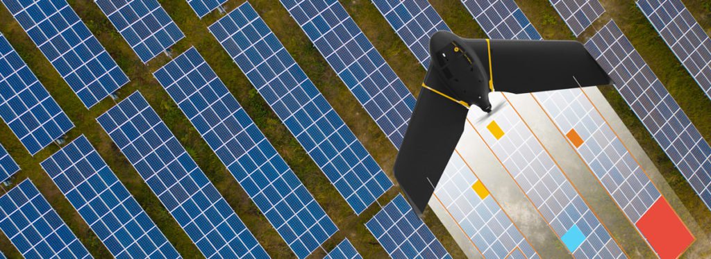
The senseFly eBee X can fly for up to 70 minutes on a single charge while carrying the senseFly Duet T thermal/RGB mapping camera. This allows 65 ha (161 ac) of sub-module level anomalies to be documented in a single 42 m (138 ft) flight — double the inspection coverage of multi-rotor systems
With Raptor Maps’ first-of-its-kind software’s minimal image requirements, users can conduct drone inspections at least five times faster than competing software
senseFly and Raptor Maps want to together set the standard for solar farm inspections. The process will be automated and as follows:
- The eBee X drone makes collecting thermographic data of solar farms easier than ever before. It captures radiometric thermal and visual RGB imagery without the need for a trained pilot
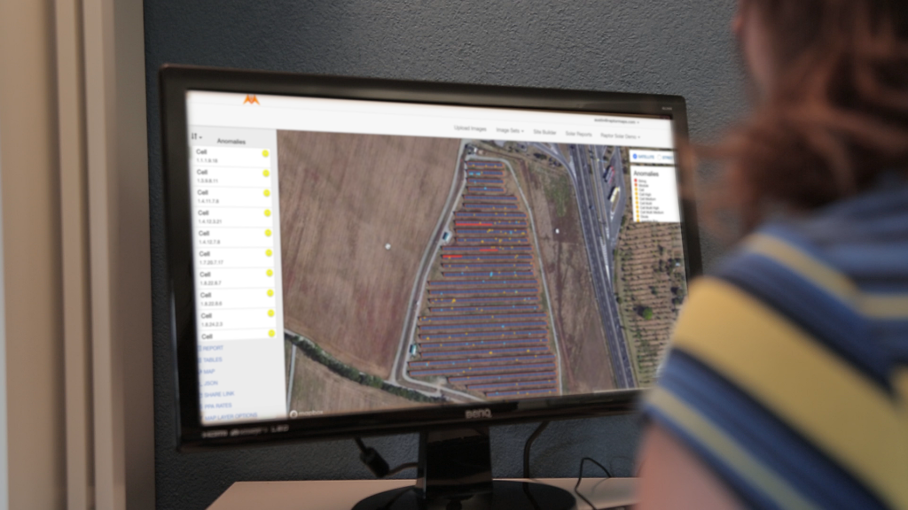
- The Raptor Maps software then generates a detailed and actionable inspection report, using the eBee X’s RGB and thermal imagery to identify, classify, and localise anomalies automatically
The Solar 360 offers profitability
senseFly suggests that Solar 360 users can breakeven in a single flight. This is because Raptor Maps users have reported $2,000/MW of previously-undetected production impact and the ability to directly replace manual electrical testing. In the case of a 16 MW site, this equates to breaking even on your senseFly Solar 360 investment after just one flight.
As with most drone-based solutions, the senseFly Solar 360 reduces staff time on-site and associated labor costs. This particular solution takes that a step further than an ordinary quadcopter because of the eBee X’s extensive single-flight coverage.
Fewer battery changes are required and the Raptor Maps software helps to drive significant cost savings by requiring 80 per cent fewer images for its analysis than competing options.
The eBee X’s RGB camera data helps to deliver further cost benefits by generating a geo-accurate digital terrain model, which can be used to optimise a farm’s design.
senseFly Solar 360 is supplied with the customer’s choice of Data Pack. These Data Packs are available in 50 MW, 100 MW and 200 MW variants, depending on the output capacity a customer expects to assess over the course of a year.
Learn more about senseFly Solar 360 here. The package will be available to order via senseFly distribution partners from June.
The new senseFly Solar 360 solution, with Raptor Maps, will be showcased on booth 2215 at AUVSI XPONENTIAL.
Malek Murison is a freelance writer and editor with a passion for tech trends and innovation. He handles product reviews, major releases and keeps an eye on the enthusiast market for DroneLife.
Email Malek
Twitter:@malekmurison
Subscribe to DroneLife here.
https://dronelife.com/2019/04/30/sensefly-unveils-solar-360-thermal-fixed-wing-solar-farm-inspections/


