6:33 pm
DJI Matrice, Drone, HEISHA, Sponsored Content
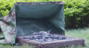
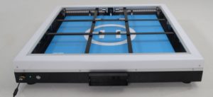
Heisha’s automated charging docks are a game changer for DJI drones like Phantom, Mavic and Inspire – and now, their revolutionary tool is available for DJI’s latest offering, the Mavic Mini. Heisha engineers are continually improving their products’ charging safety, efficiency and stability. Heisha understands user needs in a wide …
Read More »
2:54 am
Applications, Business and Finance, Drone, Drone News, Enthusiasts, HEISHA, Multi-rotor, News, Products, Selected - Products, Sponsored Content
“Unattended technologies” are those that facilitate the use of automated drones to perform tasks – not just the automation technology that allows the drone to perform its mission, but technology that allows the drone to charge its own battery. Unattended technologies are paving the way for significant advancements in surveillance, …
Read More »
8:41 am
Drone, Gremsy, Honeywell UAV, power line inspections, Sponsored Content
Transmission lines are often located in mountainous or remote areas, making on-foot or helicopter inspections difficult, time-consuming, and dangerous. Inspections rely on manual labor that doesn’t always capture accurate data for a proper assessment. Manual inspections are not only time-consuming, they’re expensive: inspecting 150 miles of power lines and 2,000+ …
Read More »
2:13 pm
aerial photography, AirMagic, Drone, Drone News Feeds, Drone Photography, Enthusiasts, News, Skylum, Sponsored Content, Uncategorized
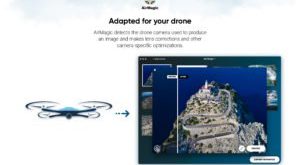
Post sponsored by Skylum. Professional drone operators in a wide variety of verticals are responsible for providing their clients with professional-quality images – but they don’t always want to invest in expensive software and spend hours in front of a computer doing the painstaking editing that requires. Introducing AirMagic – …
Read More »
7:45 pm
Applications, Business and Finance, DIY drone show, Drone, Drone News, Entertainment, geoscan, geoscan drone show, geoscan.aero, Media, Products, Sponsored Content, Video
Sponsored by Geoscan. You heard it right. Get ready to offer your clients the best and safest spectacle available – a drone show. Since the SuperBowl, the winter Olympic Games in South Korea, and shows at major events such as Burning Man, Coachella, and many others, massive drone shows have …
Read More »
3:45 pm
Applications, applications for drone pilots, Before You Buy, Business and Finance, Drone, drone buddy, Drone News, Enthusiasts, Featured - Enthusiasts, Helpful Hints, Ready to Fly, Sponsored Content
Drone pilots are a pretty awesome community. Whether Drone Nation is volunteering after an emergency, or answering questions on forums, flyers from all around the world are reaching out to help each other figure out where to fly and sharing their experiences. Now, drone pilots can get airspace intelligence and …
Read More »
11:09 pm
Applications, Drone, Drone News, First Base Solutions, SimActive, Sponsored Content
Today SimActive., a world-leading developer of photogrammetry software is being use for a large-scale project by First Base Solutions who provides aerial imagery, geospatial data and custom mapping solutions to organizations across North America. The size of each image consisted of MB totaling 40 TB of raw data. As Drones are …
Read More »
8:26 pm
BSHARK, Drone, hydrogen Drone, inspection drone, Narwhal 2, News, Sponsored Content
In the first week of production, BSHARK’s Narwhal 2 hydrogen drone sold 300 units, prompting the company to open a new production center in Shandong to meet demand. The Government of Uzbekistan has bought hundreds of units. China’s Southern Power Grid Company is using the Narwhal 2 to complete major …
Read More »
7:08 pm
Construction, Drone, Drone Education, Drone Training, Education, flir, News, Sponsored Content, STEM, STEM Thermal Imaging, Thermal Imagery
As schools, colleges and universities race to include drones into their STEM programs in order to keep up with new demand, resources are often hard to find. Drones provide a fascinating way to introduce primary and high school students to the sciences: they may provide valuable job training at higher …
Read More »
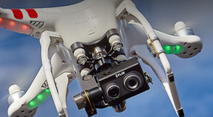
6:49 pm
Drone, Drones For Good, flir, inspection drones, News, Search and Rescue, Security drones, Sponsored Content, Thermal Imaging, Uncategorized
The team at FLIR hears about new uses for thermal imaging all the time – and as thermal imaging is adopted by more drone pilots, those use cases will continue to expand. That’s why FLIR is on a mission to get thermal to more users – and to make it …
Read More »