7:43 am
Airbus, Business and Finance, Drone, Drone News Feeds, drone transport, Drones in the News, Enthusiasts, News, Research, Technology, tom enders, Transportation, UAM, Urban Air Mobility
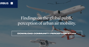
Airbus – one of several players in the race to make Urban Air Mobility (UAM) a reality – has delved into how open the public is to the idea of getting from A to B using unmanned aircraft. The report can be read in full, here. The study’s headlines are …
Read More »
11:37 am
Business and Finance, Drone, drone insurance, Drone News Feeds, flock, fly unlimited, Insurance, News, PfCO, Products, Technology, UK
UK insurtech startup Flock has launched a monthly subscription product, Fly Unlimited, to provide commercial drone operators with flexible month-to-month insurance. Complementing Flock’s existing on-demand coverage, Fly Unlimited provides a middle ground for commercial pilots flying multiple missions each month. Instead of an annual commitment with significant upfront costs, the new subscription provides …
Read More »
3:36 am
Aerospace, astigan, Business and Finance, Drone, Drone News Feeds, Enthusiasts, Fixed wing, HAPS, Imaging, mapping, News, ordnance survey, solar power, Technology, UK
National mapping agency for Great Britain and leading geospatial data organization Ordnance Survey (OS) has announced plans to launch a solar-powered drone that will fly at high altitude to complement existing satellite mapping systems. The aim of the High Altitude Psuedo Satellite (HAPS) project, called Astigan, is to provide faster, higher quality images …
Read More »
7:30 am
airports, Altitude Angel, Business and Finance, DJI, Drone, Drone News Feeds, Europe, Featured – Safety and Security, geo 2.0, News, no-fly zones, TFR, UTM
DJI has announced an update to its European geofencing technology. The Geospatial Environment Online (GEO) 2.0 system is being rolled out across 32 European countries with new measures placed around airports with help from UK drone services platform Altitude Angel. DJI to deploy “bow tie” safety zones around European airports Read …
Read More »
6:38 am
Business and Finance, Drone, Drone Harmony, Drone News, Drone News Feeds, European Space Agency, News, Switzerland, UTM
A Swiss drone company is joining forces with the European Space Agency’s initiative to rocket high-tech startups into successful orbits around the business world. Drone Harmony of Luzern, Switzerland has joined the ESA Business Incubator Switzerland, allowing the start-up to upgrade its UAS missions-planning platforms using satellite data. Created three years …
Read More »
6:24 pm
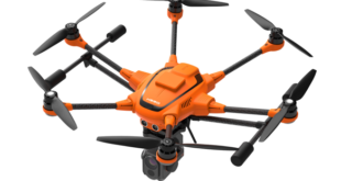
Business and Finance, Drone, Drone News Feeds, Featured - Surveying, H520 drone, Mining and Aggregates, News, Products, Real Time Kinematic, rtk, Technology, Yuneec
Drone manufacturer Yuneec has announced that its commercial hexacopter, the H520, will now be optionally available with an RTK (Real Time Kinematic) system. The addition of the RTK system from Swiss company Fixposition, means that even under difficult GPS conditions – in dense urban areas or canyons, for example – …
Read More »
6:19 am
Applications, Business and Finance, Defense, Department of Defense, Drone, Drone News, Drone News Feeds, Featured - Business, flir, News, Thermal Imaging, U. S. Army drones, U.S. Department of Defense
In a separate announcement, FLIR announced a 39.6 million dollar order to deliver FLIR Black Hornet Personal Reconnaissance Systems (PRS) for the U.S. Army. This tiny drone will support platoon and small unit level surveillance and reconnaissance capabilities as part of the initiative named the Soldier Borne Sensor (SBS) Program. …
Read More »
6:13 am
Agriculture, Applications, Business and Finance, Drone, Drone News, Drones doing good, Drones Mitigating Rats, Featured - Agriculture, Galapagos Islands, invasive species drones, News, Products, Technology
One lesser known commercial usage of drones: to identify, and in some cases to mitigate or remove, invasive species. Invasive species – in this case rats – have been a problem for the eco-system of parts of the Galapagos islands for many years. Drones have proven to be an invaluable …
Read More »
6:03 pm
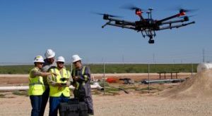
Business and Finance, BVLOS, Commercial Drones, Drone, Drone Inspections, drones, Featured - Business, Insurance, market research, News, oil and gas, PrecisionHawk, UAS, Uav, utilities
Skylogic Research, the leading commercial drone industry research and advisory services firm, just announced the release of their latest research on commercial drone operations. The Economics of Using Drones for BVLOS Inspections is a white paper sponsored by PrecisionHawk, the leading provider of drone technology for the enterprise, which provides …
Read More »
1:56 pm
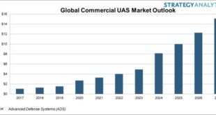
Business and Finance, commercial drone market, Commercial UAV market, Drone, Drone News Feeds, News, security drone, strategy analytics
A new report forecasts that the commercial drone market will exceed $15.1 billion by 2027. The Strategy Analytics Advanced Defense Systems (ADS) service report, “Commercial UAS Market Outlook 2017-2027” predicts that 49% of demand for commercial drone platforms by 2027 will be in the agriculture, commercial security and first responder …
Read More »