DJI has announced an update to its European geofencing technology. The Geospatial Environment Online (GEO) 2.0 system is being rolled out across 32 European countries with new measures placed around airports with help from UK drone services platform Altitude Angel.
DJI to deploy “bow tie” safety zones around European airports
Read more: UK Government Releases Report on Drone Regulation Consultation, DJI Responds
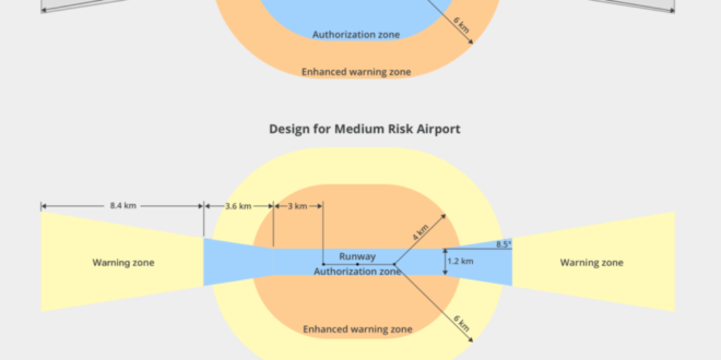
In a timely move following recent incidents at London’s Gatwick and Heathrow airports in recent weeks, DJI’s GEO 2.0 creates a detailed three-dimensional “bow tie” safety zone around airports. This better accounts for runway flight paths than the previous circular geofence.
GEO 2.0 also uses complex polygon shapes around other sensitive facilities. This adapted approach now applies in the 13 countries covered by DJI’s original GEO system on top of 19 new countries across Europe that previously did not have advanced geofencing.
The bow tie approach is designed to better reflect the actual safety risk posed in those areas.
According to a statement from DJI, the GEO revamp will also include Temporary Flight Restrictions (TFRs) imposed during major events or natural disasters. These will be based on data from Eurocontrol.
DJI’s GEO 2.0 offers smarter airport coverage than previous iterations.
DJI partners with Altitude Angel
Toward the end of 2018, DJI announced similar changes to its Geofencing across the United States, as well as ditching previous data supplier AirMap for PrecisionHawk.
For its European customers, DJI has chosen to swap AirMap for new partner Altitude Angel. The UK company will be tasked with delivering accurate, real-time and relevant geospatial data for airports, TFRs and other sensitive areas across 32 European countries.
DJI worked together with Altitude Angel last year in Operation Zenith, a full-scale UTM test at Manchester Airport.
“DJI is eager to ensure that safety remains the top priority as the European drone industry innovates new ways to use drones in exciting and productive ways. Introducing state-of-the-art safety features in even more countries will help the general public and drone operators alike,” said Christian Struwe, DJI’s Head of Policy, EMEA.
“European airspace management must accommodate advanced future operations, such as automated flight and flight beyond the operator’s line of sight, without imposing new burdens on recreational and professional drone pilots who have completed millions of safe and beneficial flights. Altitude Angel supports this vision and supplies the reliable airspace data needed to implement it.”
Richard Parker, Founder & Chief Executive Officer of Altitude Angel, said, “We are honored to partner with DJI on this important update to GEO and look forward to working closely on other important projects. We work hard to deliver the best data and drone services to our customers globally, and we welcome DJI’s recognition of the value in our Guardian platform to enable their customers to fly safely and access more airspace“.
Read more: 5 Technologies Improving Drone Safety
Europe’s GEO 2.0 timetable
The upgrade to GEO 2.0 will be phased in across Europe towards the end of February. DJI flyers will need to update their DJI GO 4 flight control app and aircraft firmware to make sure the new system is implemented.
You can read more about GEO 2.0 here.
Malek Murison is a freelance writer and editor with a passion for tech trends and innovation. He handles product reviews, major releases and keeps an eye on the enthusiast market for DroneLife.
Email Malek
Twitter:@malekmurison
Subscribe to DroneLife here.
https://dronelife.com/2019/02/12/dji-rolls-out-geo-2-0-across-europe-with-new-partner-altitude-angel/


