5:04 am
adobe creative cloud, anafi, Business and Finance, Drone, Drone News Feeds, Enthusiasts, extended, HDR+, News, Parrot, Products
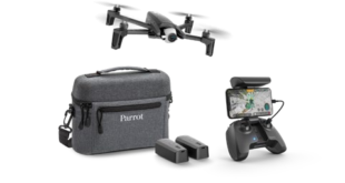
Parrot have launched Anafi Extended, a package that includes three batteries for a total flight time of over one hour. Anafi’s software has also been updated with a number of new flight modes and camera features. Parrot is has been pushing the Anafi hard since its release. In August the …
Read More »
8:47 am
Drone, drone business, Drone Law, Drone News Feeds, DroneLaw.pro, Enrico Schaefer, Feature 1, News, Traverse Legal
Enrico Shaefer, DroneLaw.pro DRONELIFE is excited to announce a new collaboration with drone attorney and business expert Enrico Schaefer, of Traverse Legal, PLC and Drone Law Pro. Welcome to the first edition of From the Ground Up: a podcast series designed to help drone businesses level up and grow. Enrico …
Read More »
12:42 pm
Aircraft Certification, Drone, Drone News Feeds, FAA, Insitu, News, ScanEagle, Sense and Avoid
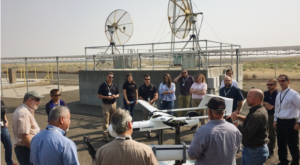
FAA teams examine Insitu’s ScanEagle3 at a Type Certification Board Meeting in Bingen, Washington. Insitu, a wholly-owned subsidiary of The Boeing Company, is playing the long game. The company is drawing from Boeing’s experience as the world’s largest aerospace company and planning for the future with the ScanEagle 3, collaborating …
Read More »
8:39 pm
DJI, Drone, Drone News, Drone News Feeds, News, Robomaster, Technology
Drone-industry leader DJI is launching its fifth international robotics competition and engineers from around the word are all invited to compete for more than $100,000 in cash prizes. The fifth annual RoboMaster Competition is open to all universities and students with a passion for engineering and technology. “What’s unique about …
Read More »
4:37 pm
airspace security, Commercial Drones, DJI, Drone, LATAS, News, PrecisionHawk, UTM
The following is press release from PrecisionHawk. PrecisionHawk’s Low Altitude Traffic and Airspace Safety (LATAS) platform to replace AirMap PrecisionHawk, Inc. today announced a partnership with DJI, the world’s leader in civilian drones and aerial imaging technology, to improve its geofencing technology. Leveraging PrecisionHawk’s Low Altitude Traffic and Airspace Safety …
Read More »
12:37 pm
AirMap, DJI, Drone, Drone News Feeds, Feature 1, GEO, geospatial data, News, PrecisionHawk
DJI has announced improvements to its geofencing technology. The move will refine airspace limitations for drone flights near airports to provide better protection to airplanes in sensitive areas. The GEO update will be backed by geospatial data from PrecisionHawk, replacing Airmap, the Santa Monica-based company DJI had been working with since …
Read More »
8:29 am
Amazing Footage, deer, Drone, Drone News Feeds, Drones in the News, Enthusiasts, Lincolnshire, News, Poaching, Police, Video
The UK is famous for many things but an abundance of exotic wildlife isn’t one of them. Which means the police have to take special measures to keep what little they do have intact. Lincolnshire Police have a fleet of drones to help with event security, tactical operations and more. …
Read More »
8:26 pm
BSHARK, Drone, hydrogen Drone, inspection drone, Narwhal 2, News, Sponsored Content
In the first week of production, BSHARK’s Narwhal 2 hydrogen drone sold 300 units, prompting the company to open a new production center in Shandong to meet demand. The Government of Uzbekistan has bought hundreds of units. China’s Southern Power Grid Company is using the Narwhal 2 to complete major …
Read More »
4:25 pm
Drone, Drone News, Drone News Feeds, Embry-Riddle Aeronautical University, News, UTM
A recent study reveals that a growing number of amateur drone users are creating new dangers with risky flights. Florida-based Embry-Riddle Aeronautical University released the study this week estimating that “only 12 percent of all detected drones were flying near unimproved land and parks.” “More than three-fourths were flying in …
Read More »
8:23 am
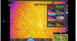
Business and Finance, Drone, Drone News Feeds, dronesense, emergency, Featured – Safety and Security, First Responders, flir, News, Products, Search and Rescue, software platform, Technology
Thermal imaging specialists FLIR Systems have plenty of interest in the drone industry, particularly when it comes to public safety. The Oregon-based company partnered with DJI earlier this year to launch the Zenmuse XT2, a dual optical and thermal camera designed to support firefighters and first responders. Now the company …
Read More »