4:10 pm
chinese drone industry, Drone, Drone News Feeds, EHang, News, Passenger Drones, UTM
Ehang is back. The company that wowed at CES back in 2016 with the first prototype of the Ehang184 Autonomous Aerial Vehicle (AAV) for passengers announced today that they have been authorized as China’s first pilot company to develop passenger drone programs. “On January 23rd, 2019, the Airworthiness Department of …
Read More »
12:08 pm
Canadian drone industry, Drone, Drone News Feeds, IN-FLIGHT drone, News, senseFly
Canadian drone company IN-FLIGHT Data has been awarded three GUINNESS WORLD RECORDS™ for groundbreaking Beyond Visual-Line-Of-Sight (BVLOS) projects supported by senseFly. The following is a senseFly and IN-FLIGHT Data press release. Calgary, Canada / Cheseaux, Switzerland, February 18, 2019 —IN-FLIGHT Data, one of Canada’s leading commercial drone operators, has been awarded …
Read More »
3:51 pm
Drone, Drone News Feeds, Drone Restrictions, FAA, Feature 1, LAANC, News, US Drone Laws
Matthew G. Bisanz [CC BY-SA 3.0] After the recent government shutdown, the FAA seems to be making up for lost time. In the past 3 days, the agency has made 3 announcements concerning drone regulations. On February 13, the FAA announced a major change to the registration marking rule. At …
Read More »
7:43 am
Airbus, Business and Finance, Drone, Drone News Feeds, drone transport, Drones in the News, Enthusiasts, News, Research, Technology, tom enders, Transportation, UAM, Urban Air Mobility
Airbus – one of several players in the race to make Urban Air Mobility (UAM) a reality – has delved into how open the public is to the idea of getting from A to B using unmanned aircraft. The report can be read in full, here. The study’s headlines are …
Read More »
3:39 pm
Drone, Drone ID and Tracking, drone laws, Drone News Feeds, drone rules, FAA, Feature 1, News
Coming February 23: a new rule from the FAA about displaying registration numbers. Now, registration numbers must be clearly marked on the outside of the drone. ” The Federal Aviation Administration (FAA) has posted a rule in the Federal Register requiring small drone owners to display the FAA-issued registration number …
Read More »
11:37 am
Business and Finance, Drone, drone insurance, Drone News Feeds, flock, fly unlimited, Insurance, News, PfCO, Products, Technology, UK
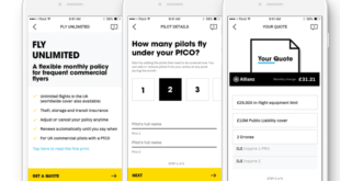
UK insurtech startup Flock has launched a monthly subscription product, Fly Unlimited, to provide commercial drone operators with flexible month-to-month insurance. Complementing Flock’s existing on-demand coverage, Fly Unlimited provides a middle ground for commercial pilots flying multiple missions each month. Instead of an annual commitment with significant upfront costs, the new subscription provides …
Read More »
3:36 am
Aerospace, astigan, Business and Finance, Drone, Drone News Feeds, Enthusiasts, Fixed wing, HAPS, Imaging, mapping, News, ordnance survey, solar power, Technology, UK
National mapping agency for Great Britain and leading geospatial data organization Ordnance Survey (OS) has announced plans to launch a solar-powered drone that will fly at high altitude to complement existing satellite mapping systems. The aim of the High Altitude Psuedo Satellite (HAPS) project, called Astigan, is to provide faster, higher quality images …
Read More »
7:30 am
airports, Altitude Angel, Business and Finance, DJI, Drone, Drone News Feeds, Europe, Featured – Safety and Security, geo 2.0, News, no-fly zones, TFR, UTM
DJI has announced an update to its European geofencing technology. The Geospatial Environment Online (GEO) 2.0 system is being rolled out across 32 European countries with new measures placed around airports with help from UK drone services platform Altitude Angel. DJI to deploy “bow tie” safety zones around European airports Read …
Read More »
3:06 pm
AskDroneU, commercial drone operators, Drone, Drone News Feeds, Drone Training, DroneU, Feature 1, News, Pix4D
An insider look at DroneU and Pix4D‘s Accident Scene Reconstruction Training for Drone Operators. The following is a Guest Post by Paul Aitken, the Chief Pilot, and co-founder of Drone U, and co-host of the popular Ask Drone U podcast. Anyone familiar with drone mapping may understand the long list …
Read More »
11:05 am
Anti-drone technology, counter drone technology, Counter UAS, Drone, drone grenade, Drone News Feeds, net, News, Patent, Products, Technology, us army
There are several problems with shooting drones out of the sky. Often that level of force is going to make the problem worse, not better. For starters, a damaged or busted drone could crash land anywhere or on anyone. The uncertainty and danger grow exponentially if it’s strapped with explosives …
Read More »