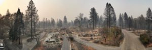
While California’s Camp Fire has earned the infamous title of costliest world disaster of 2018, the aftermath could have been worse, say fire experts, had it not been for drones.
The series of wildfires claimed more than 80 lives and destroyed thousands of buildings across Butte County. However, thanks to UAV companies DJI and DroneDeploy, county and state agencies were able to maximize both disaster response and damage assessment over some 17,000 acres of ravaged landscape.
A cadre of 16 drone teams, led by Alameda County Sheriff’s Office, Stockton Police, Contra Costa County Sheriff’s Office and other agencies, launched 516 flights using DJI Phantom 4 platforms coupled with software analysis by DroneDeploy to collect 70,000 images resulting in 1.4 trillion pixels of data over a two-day period.
Following collection, the data was transported to DroneDeploy’s San Francisco headquarters office for processing. Given the lack of cell and data networks at the fire sites, teams delivered the data via old-school physical disk. DroneDeploy’s team created a detailed, interactive map within a day after receiving the drone images and data.
After the imagery was georeferenced and stitched into a map format, Butte County officials posted a public fire map to help residents and officials assess the damage.
The detailed footage and maps help determine the condition of homes, which in turn can expedite insurance claims. The data also assists recovery crews, demolition crews, city planners, scientists and researchers, and the general public, to get a better understanding of the situation.
“We’re hoping that one, it will help people understand the devastation that we’re dealing with, understand the very difficult task that we have,” said Butte County Sheriff Kory Honea. “We’re hoping it’ll provide them information that will help them get their insurance claims started.”
“Wildfire victims also made good use of the maps. With entire neighborhoods mapped, homeowners were able to submit the imagery to insurance providers to process claims immediately — a process that traditionally can take days or weeks. Many have used the imagery to gain access to FEMA relief funds for the families affected by the fires.”
Jason is a longstanding contributor to DroneLife with an avid interest in all things tech. He focuses on anti-drone technologies and the public safety sector; police, fire, and search and rescue.
Beginning his career as a journalist in 1996, Jason has since written and edited thousands of engaging news articles, blog posts, press releases and online content.
Email Jason
TWITTER:@JasonPReagan
Subscribe to DroneLife here.
https://dronelife.com/2019/01/08/california-drones-stitch-helpful-aerial-maps-in-wake-of-deadly-camp-fire/
 Unmanned Aerial Vehicle The latest drone news


