 DroneDeploy, a leading provider of cloud-based drone software and mapping solutions, announced today that they have partnered with agriculture-focused analytics company Aglytix and ag-tech company AgriSens to provide new tools in time for the growing season. The two new tools, designed to offer actionable insights about plant count and stand establishment, demonstrate the growing influence that drones are having on precision agriculture.
Stand Analysis by Drone
While evaluating crop stand establishment – determining the uniform germination and emergence of the plants, a critical element in the success of commodity crops – has generally been a tedious and imperfect job involving on-the-ground sampling, DroneDeploy’s new tool from Aglytix allows farmers to get an accurate classification of an entire field. Aglytix’s analytical Solver takes a DroneDeploy map of an emergent crop like corn or soybeans and creates a shapefile and report detailing crop emergence throughout the field. DroneDeploy describes the comprehensive output:
The analysis calculates the economic loss on the field and offers the opportunity to take preventive or corrective actions to mitigate seed emergence issues. Output includes detailed stand gap mapping, a PDF report highlighting the economic impact, and a zoned shapefile that you can use to make better decisions about where to where to apply inputs.
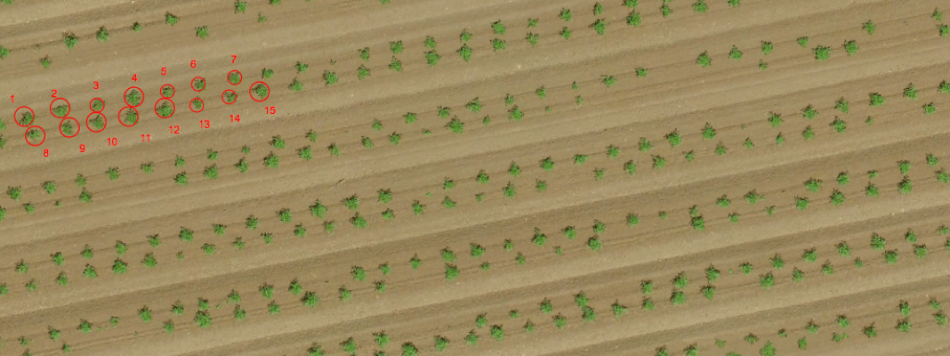
A Faster Way to Count Crops
The second new tool, developed with AgriSens, combines aerial imagery with computer vision to help growers count individual plants. The tool leverages DroneDeploy’s sophisticated mapping to provide accurate information about plant growth for seasonal crops, and will help growers keep track of plant count in perennial plantations by counting individual plants on the mapped area.
The use of drones in agriculture is expanding rapidly as new tools make the technology more available – and valuable – to growers of all sizes. According to a recent report by RNRMarket analysts, the worldwide market for agricultural drones is currently $494 million – and is anticipated to reach $3.69 billion by 2022. “Agricultural drone technology has reached a level of maturity that has put these systems at the forefront of farming modernization. Farmers around the entire world are adapting to drone availability, using aerial cameras to visualize plants,” says the report.
More information about the DroneDeploy tools mentioned above (including trial information) can be found on the DroneDeploy website.
Source link


