In October of 2017, we published a story about DroneDeploy‘s huge growth: “In just this year, the company has mapped more than 25 million acres, representing an area larger than the country of Iceland. They’ve processed 40 million images in 2017, create thousands of maps every day, and have processed 750k measurements on the platform so far this year.”
What does all that mean? Lots and lots of experience, and lots and lots of data – enough data, says DroneDeploy’s CTO Nick Pilkington, to usefully apply to machine learning. That’s just what the company has done with Map Engine, DroneDeploy’s cloud-based photogrammetry and image processing software. Previously in beta mode – it’s already used by over 4,000 customers worldwide, processing over 30,000 maps a month – the product launched officially today.
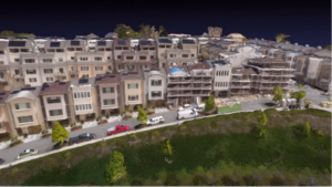
“Map Engine tracks billions of points in aerial images to simultaneously reconstruct 3D scenes and the trajectory of the drone,” said Pilkington. “We have brought together the latest advances in cloud computing, computer vision, and machine learning to build a best-in-class photogrammetry pipeline that delivers accurate results in record time— no matter your workflow.”
Map Engine is made specifically for the cloud, so maps and models process quickly taking advantage of the latest cloud infrastructure and machine learning hardware. “Even maps with up to 10K images can be processed without sacrificing quality, and using the cloud means cutting on-premise hardware, engineering, and IT costs,” says DroneDeploy. It’s a big step for the industry – and the addition of machine learning means that the faster processing is generating more actual information.
Intelligent photogrammetry with machine learning takes mapping to the next level. Map Engine is able to interpret and understand scenes, so that it can make processing decisions and deliver the sharpest and most accurate results in the shortest amount of time.
“Machine learning was built into the product from the beginning,” says Pilkington. “Now it’s coming to fruition.”
“We have five years worth of data and experience,” explains Pilkington, “and with those huge amounts of data we can now tie in things like AI and machine learning.” Map Engine can do things like help with mapping agricultural fields of soy or corn, or water, where it can be hard for the human eye to determine edges or boundaries: but easy for a computer to do it. It can improve the quality of images for construction that might be used to measure distances and volumes. It can distinguish trees from buildings, and give more value in post-processing, doing things like counting the solar panels on a solar field.
It’s the culmination of years of work. “The Map Engine codebase integration began two years ago with DroneDeploy’s acquisition of leading photogrammetry solution 3DN, which had already been in development for five years,” says a DroneDeploy press release. The company has put time, energy and money into the project: they’ve had 5 PhDs with impressive backgrounds and years of experience working on the machine learning side.
“We have been working on these hard problems for a long time,” says Pilkington.
The work will continue. Pilkington says DroneDeploy is already at work on harder processing challenges. “Getting high resolution GPS with ground control points is tedious and time consuming for humans to do,” says Pilkington. “It’s a big problem; but by having access to and learning from large amounts of data we can make this process easier.”
“The way that we think about it, the [ultimate] goal is full autonomy: there will be drone on every job site, and it will be simple and accessible and usable,” says Pilkington. “We’re working on a one-button experience.”
From DroneDeploy’s press release:
This release includes four major improvements over earlier beta versions:
- Improved Speed: Map Engine now generates maps and models 30-50% faster. Scenes made up of hundreds of images can be processed in under an hour.
- Improved Accuracy: Industry-specific accuracy improvements for Agriculture, Construction, and Solar generate higher-quality results.
- Large Map Support: Maps of up to 10,000 images (100GB) can now be quickly and accurately processed (in beta).
- Mobile Uploads: Customers can now wirelessly transfer images to the cloud with Mobile Uploads (in beta) for immediate processing.
https://dronelife.com/2018/08/21/dronedeploy-introduces-the-worlds-first-machine-learning-driven-drone-map-processing-engine/


