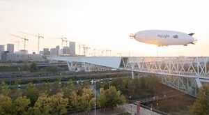
External Feed

BVLOS Flight, No Visual Observers: Volatus and FlightOps Rec…

Volatus Aerospace with FlightOps OS Receives Canada’s First Certificate for BVLOS flight, no visual observers. by DRONELIFE Staff Writer Ian M Crosby Volatus Aerospace, using the FlightOps OS, has become the first company in Canada to obtain a Beyond Visual Line of Sight (BVLOS) Special Flight Operations Certificate (SFOC), authorizing …

Read More »

WGIC JOINS INTERGEO AS STRATEGIC PARTNER

The Hague, The Netherlands, August 29, 2022 – The World Geospatial Industry Council (WGIC) and German Association for Geodesy, Geoinformation and Land Management (DVW e.V.) are pleased to announce a strategic partnership that will ofINTERGEO as a global and vibrant platform. Both organizations will work towards enriching the INTERGEO 2022 …

Read More »

Iran’s regime sought tech for nuclear weapons, say Swedish a…

(August 28, 2022 / JNS) The Islamic Republic of Iran’s efforts to secure illicit nuclear technology is detailed in an intelligence report recently released by Sweden’s Security Service. According to the Swedish Security Service Yearbook report released in March, which covers the year 2021, “Iran also conducts industrial espionage such as primarily …

Read More »

A São Paulo Airport Is Using Drones To Patrol Its Surroundin…

The São Paulo Guarulhos International Airport (GRU) has begun using drones as part of its Security Work Plan. In recent days, GRU Airport, the concessionaire that manages the airport, acquired two unmanned aerial vehicles from Dahua Technology to monitor and protect the hub’s perimeter. Security drones More often than not, …

Read More »

Army receives swarm drones, eyes light tanks to check PLA | …

The Indian Army’s mechanised forces are inducting swarm drone systems capable of carrying out offensive missions in enemy territory with scores of drones working in formations to identify, encircle and strike targets even as a proposal to develop light tanks for rapid deployment and high mobility in mountains to counter …

Read More »

Planting Trees with Drones AirSeed

CAL International Partners with AirSeed Technologies for Drone Reforestation Initiative, planting trees with drones. by DRONELIFE Staff Writer Ian M Crosby Smart tech and engineering firm CAL International has formed a partnership with Australian green tech company AirSeed Technologies for a major climate change project that will employ aerial platform …

Read More »

Global Mapper Mobile: New GNSS Device Support

Introducing Global Mapper Mobile’s New GNSS Device Support via TCP/IP Communication Global Mapper Pro is a powerful geospatial data analysis program that contains tools for everything from raster image processing to photogrammetric point cloud creation with the Pixels to Points tool. Designed to work alongside Global Mapper Pro, the free …

Read More »