Flying a drone is very different from flying a plane or driving a car. For starters, it’s remote. The separation between pilot and vehicle means there’s limited accountability built into the situation.
And that’s an issue. If you want to reassure members of the public and law enforcement that what you’re doing is above board, society’s usual methods of integrating accountability into these kinds of situations – (1. Actually sitting in the driving seat and 2. Having your personal details connected to a visible license plate) – aren’t really feasible.
For some commercial operations, a drone pilot on the ground nearby, wearing a hi-vis jacket and generally being conspicuous is enough to provide the credibility needed. But looking forward, that basic solution clearly doesn’t go far enough.
Which is why there is a general consensus that remote identification is a necessary step before more advanced drone operations can take off at scale. Companies are lining up to use drones for flights at night or beyond visual line of sight. And that’s before we get to the more ambitious projects turning drones into personal transport vehicles and taxi services.
The concept of Remote ID, of drones effectively broadcasting their location, flight intention and pilot’s details, is also seen as fundamental to a working UTM.
Just imagine how useful the capability could be in light of recent events in London. No doubt it would help when law enforcement are, for example, attempting to identify whether a light in the sky is a drone flying where it shouldn’t, a police helicopter looking for a drone, a police drone looking for a drone… or just a crane. You can read more on that here.
Read more: DJI Refines Geofencing and Ditches AirMap for PrecisionHawk
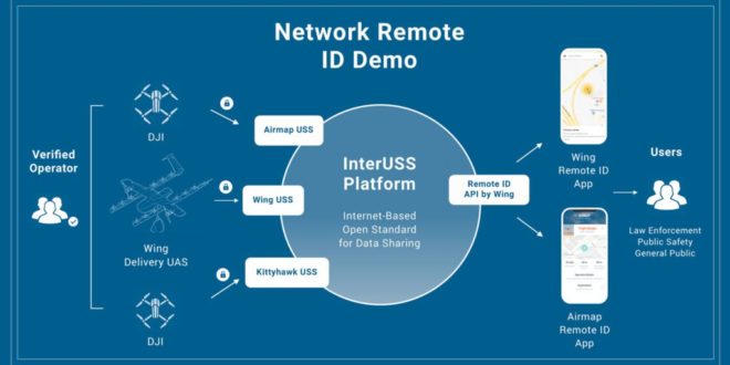
Wing, AirMap & Kittyhawk demo network drone ID solution
While most agree that Remote ID is needed, there are disagreements over the best path forward. It’s important to devise a system that isn’t a burden on operators or an unnecessary infringement upon privacy rights.
This week it emerged that three UAS Service Suppliers helping to run the FAA’s LAANC program – AirMap, Wing and Kittyhawk.io – demonstrated a network-based remote ID application back in December using the open-source InterUSS platform.
InterUSS is a project set up by Wing. The aim is to inform third parties about what drones are operating near their current location and why. That could include the general public, other drone pilots or law enforcement. In the case of Wing’s delivery service, the company is keen for the public to know (and ultimately have confidence in) their drones buzzing around overhead.
The demonstration consisted of three operators and three drones, 2 from DJI and 1 from Wing Delivery. Each operator logged into their provider (Wing, AirMap, and Kittyhawk.io) with a validated identity.
Then, each operator requested airspace access authorizations for their flights through their platform’s LAANC approval capabilities. InterUSS was used to discover which service providers were operating drone flights in the area, before providing relevant drone data to the separate remote identification applications.
The system, outlined in the image below, meant that flight and pilot data was shared only as needed. To protect operator privacy, only safety information was shared to non-participating bystanders, who were able to visualize the drone operations in their vicinity in real time on a smartphone application.
Read more: Insurance Company Travelers Invests $3M in Kittyhawk
“Before such wide-scale drone operations as autonomous deliveries can take place, we need to ensure that regulators – and the public – can easily assess whether or not a particular drone belongs to a good actor or requires intervention,” said Ben Marcus, Co-Founder and Chairman of AirMap.
“Network-based remote identification applications like AirMap’s Drone Aware, augmented by local broadcast solutions when available, help airspace managers enforce aviation regulations while cultivating public trust in drone and also protecting the privacy of drone operators.”
In a company blog post, Kittyhawk founder Joshua Ziering points out that network-based remote ID fits the criteria of an accessible, low-cost solution.
“It doesn’t require any special hardware, it allows multiple parties to both consume and populate the data, and with the power of technologies like LTE and the forthcoming 5G, it will be readily accessible to the largest amount of people with the smallest amount of overhead.
Kittyhawk remains dedicated to a safe and secure National Airspace. We think that transparency, inclusion, and collaboration amongst not only USS but all stakeholders in the commercial drone industry are paramount to enabling progress,” he wrote.
Malek Murison is a freelance writer and editor with a passion for tech trends and innovation. He handles product reviews, major releases and keeps an eye on the enthusiast market for DroneLife.
Email Malek
Twitter:@malekmurison
Subscribe to DroneLife here.
https://dronelife.com/2019/01/17/airmap-kittyhawk-and-wing-demonstrate-interuss-remote-id-solution/


