 A California-based company has teamed up with the world’s largest drone manufacturer to build an anti-drone fence around wildfires.
AirMap, a provider of UAV airspace intelligence and navigation services, announced a partnership last week with DJI to enhance its current geofencing data database to include areas experiencing wildfires.
Errant drones have become a real problem for firefighters as several wildfires continue to spread in Western states this summer.
The company’s virtual fence will corral drones away from wildfire sites and ensure firefighting aircraft stay out of danger. Several recent drone-related incidents have forced officials to ground manned aircraft over wildfires due to near-misses with drones.
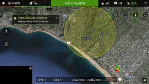
The company will harvest wildfire-location data directly from the Department of Interior and transmit it to drone pilots via its flight-control apps and AirMap’s geofencing system native to DJI’s GO flight control app.
“This data is more current and includes more active wildfires than Temporary Flight Restrictions published by the FAA,” an AirMap press release stated.
Over the summer, the Interior department’s data system has logged more than 300 new wildfires daily during summer fire season. The AirMap-DJI partnership will integrate the GO app’s geofencing system with AirMap’s data stream and can be used to mark restrictive airspace near wildfires, airports, prisons, nuclear power plants and other high-security or restricted airspace.
“AirMap delivers dynamic airspace intelligence to unmanned aircraft in order to provide the safest operating environment possible,” said Ben Marcus, CEO of AirMap. “Through our partnership with DJI and other drone manufacturers and application developers, more than 70 percent of the drones operated in the United States now benefit from wildfire information in real time.”
“DJI wants to equip its customers with safety-critical information that will help our first responders, whether or not a TFR has been issued,” said Brendan Schulman, DJI Vice President of Policy and Legal Affairs. “This enhancement to GEO will help prevent DJI drones from inadvertently taking off within, or flying into, a wildfire location without authorization.”
Several states are already responding to the dangers of drone-wildfire interference. Earlier this month, the governor of Utah called a special legislative session in an effort to mandate stiff penalties for drone operators who fly over wildfires.
“This summer, wildfires in the state have become significantly worse due to drones interrupting air operations,” Gov. Gary Herbert said in a statement. “It is dangerous and completely unacceptable, and this legislation takes steps to ensure that our emergency management personnel are safe and empowered to do their jobs effectively.”
Source link


