
Madrid, December 10, 2021
UAV Navigation recently performed remote support to one of their Australian customers using their Visionair CloudLink technical support tool. Using this software, UAV Navigation was able to monitor the client’s platform in real time during the flight carried out and confirm the gains that define the correct operation of the system and, therefore, of the platform.
As stated by the Product Owner of the GCS Visionair software for UAV Navigation, Jorge López, this tool “aims to provide the UAV Navigation team with a mechanism to diagnose and solve possible problems with customer platforms remotely.“
UAV Navigation is aware of the need to provide remote support to customers in relatively critical situations (eg: demonstration to end customers), and wants to respond to this need in order to provide the highest quality support on the market.
“Our direct competitors do not have a similar service,” says Carlos Lázaro, head of UAV Navigation’s commercial department. Visionair CloudLink requires lower bandwidth than other commercially available tools and requires no license and therefore third-party dependency.
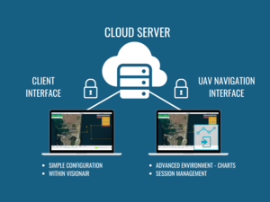
The concept of operation that is proposed tries to fill the connectivity deficiencies of the existing mechanisms until now, adding an extra component that is the “cloud server”, to which both the client and the support engineer (UAV Navigation) can connect. The sessions to which the different clients can connect simultaneously are managed in the “cloud server”. Through the internet and through an encrypted connection, when both nodes are authenticated, the server establishes a communication gateway between them, remaining virtually connected to each other.
“This application restricted to UAV Navigation engineers allows us to provide a premium support service to our customers.” indicates Carlos.
This is a practical example of how the new tool developed by UAV Navigation can help the technical support of clients anywhere in the world and connect remote places like Spain and Australia in a secure and confidential way.
About UAV Navigation:
UAV Navigation is a company that has specialized in the design of guidance, navigation, and control solutions for Unmanned Aerial Vehicles (UAVs) since 2004. UAV Navigation offers a wide range of Unmanned Aerial Vehicles (UAV) solutions. The UAVs, also known as Remotely Piloted Aircraft Systems (RPAS) or ‘drones’ refer to high-performance tactical unmanned planes, aerial targets, mini-UAVs, and helicopters. To deliver the most appropriate flight control and inertial navigation solutions, UAV Navigation classifies the autopilots based on two factors — reliability and strength. UAV Navigation’s flight control solutions equip UAVs with over 60,000 flight hours in all kinds of weather and on all types of platforms. So, anything that a human pilot can fly, UAV Navigation’s autopilot can. www.uavnavigation.com