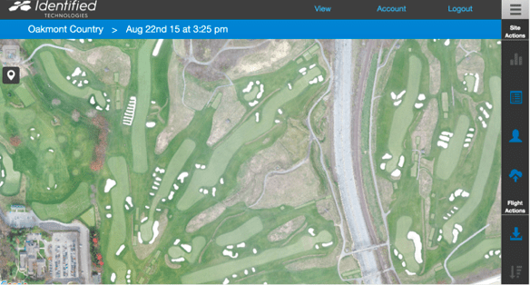
On a cold October morning, a drone begins its mission. Flying over all 7,255 yards of greens, the drone is watching, learning, tracking. The U.S. Open will be held here at Oakmont, hosting the worlds best golfers on a legendarily challenging course.
Possibly the hardest golf course in America, Oakmont prides itself on bringing the best to their knees, with golfers looking to merely survive, rather than thrive, on this 18 hole gauntlet. “There’s a reason [the U.S. Open] is coming back to Oakmont. This really is the golf standard for championship golf. It doesn’t get any better than Oakmont.” Said USGA Director of Rules, Mike Davis.
In order to craft this excruciating course, directors need to understand what the layout of the course looks like from all angles. The massive size of these links makes it difficult for course managers to see all parts of their course, so they’re taking a cutting edge approach to mapping: smart aerial drones.

*The Histrorical “Church Pews” Bunker at Oakmont Country Club
Flying 400 feet above the greens, Identified Technologies is using their self-piloting commercial UAV, mapping every square inch of the prestigious golf course. “It’s an honor to be able to use our technology to help with something that I’ve grown up loving” said Dick Zhang, a New Jersey State Ranked Golfer, and the Founder and CEO of Identified Technologies.
“We have primarily used our drone mapping technology for construction and mining, as well as oil and gas projects. We normally work with regional leaders like EQT and P.J. Dick, but when the USGA contacted us, I knew that I couldn’t pass this opportunity up. My golf coaches instilled the discipline and focus in me, that we now direct towards building this company. If it wasn’t for golf, this company would not exist. The United States Golf Association is using these maps from an operations standpoint, looking for the best logistical blueprint on how to set up stands, booths, walking areas, and more. What used to take a month and cost tens of thousands of dollars can now be done in minutes at a fraction of the cost.” said Zhang, “Getting continuous 3D project tracking dramatically improves our clients’ speed, safety, quality, and profit margins.”
Founded in 2013 by Zhang, Identified Technologies has hand-picked many of the brightest stars from Carnegie Mellon’s robotics department to develop a self-piloting Boomerang drone system which can map a 100 acre construction site in under 10 minutes vs 1-2 months for a manned survey team. The Boomerang drone achieves high resolution accuracy comparable to traditional aerial surveys for a small fraction of the time and cost.
CTO, Steven Blass said “We are proud of what we have built here. We’re working hard every day to stay on the cutting edge of drone mapping.” Coming off $3.5 million in funding led by Birchmere Ventures, major industrial customers from around the country are taking notice and taking to the skies.
Other sports are using drones as well. UCLA began using quadcopters to record their practices from an aerial perspective, as well as racing, skiing, motorcross, and many others. Analytics are a huge aspect to any business, for both professional sports and industry as a whole, which is pushing the drone movement out of the early adopter phase. “It used to be that many people didn’t truly understand how these drones can help make their work easier and more efficient. Now people get it, and are looking to make this technology a part of their daily operations. Major players in these industries are coming to us saying ‘This is exactly what we’ve been looking for’, which great for both us, and the commercial drone industry as a whole.”, says Zhang.
As the players tee off at Oakmont, viewers will see a pristine U.S. Open course. What many will not realize is that cutting edge technology from the drone industry helped to make this happen, with more to come in the future. “I’ll be watching my favorite sport this weekend, taking great pride knowing our mapping drones helped make it happen” said Zhang, “I never thought I’d see my two greatest passions come together!”
Source link


