During spring and summer supercell thunderstorms roam through the central United States, bringing with them lightning, huge hailstones and dangerously high winds.
Some develop tornadoes, and a collective of atmospheric scientists led by the University of Nebraska-Lincoln are using drones to better understand why.
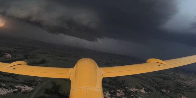
The TORUS research project (Targeted Observation by Radars and UAS of Supercells) will be carried out by over fifty scientists and students. They will be deploying a broad suite of cutting-edge instrumentation into the US Great Plains during the 2019 and 2020 storm seasons, including four fixed-wing drones.
TORUS will use data collected by four drones to improve the conceptual model of supercell thunderstorms and the formation of destructive tornadoes.
Read more: Naval Research Drones Shine in Solar Research
Atmospheric investigations from above
The $2.4-million project will send four drones directly into the storms to gather data at an altitude of nearly 800 metres.
“We are attacking the storm from every angle to see what is going on,” Brian Argrow, an aerospace engineer at the University of Colorado Boulder leading the TORUS drone team told Nature.
The researchers and students will split around twelve teams and, over the course of the storm seasons in 2019 and 2020, chase supercell thunderstorms in the 950,000-square-kilometre regions that stretch from North Dakota to Texas, and from Iowa to Wyoming and Colorado.
The National Science Foundation is funding the majority of the TORUS research project.
Read more: AT&T’s All-Weather Drone Takes Off In Time For Hurricane Season
Read more: Drones are Proving Their Worth in Fire and Emergency Services
The TORUS project will use drones alongside three mobile radars, eight mobile mesonets (trucks mounted with meteorological instrumentation), a mobile LIDAR, three mobile sounding systems (balloon-borne sensor packages), and an NOAA P3 manned aircraft to uncover the composition of severe storms.
The aim is to gather enough data to better understand supercell thunderstorm behavior and improve supercell and tornado forecasts in the process.
Malek Murison is a freelance writer and editor with a passion for tech trends and innovation. He handles product reviews, major releases and keeps an eye on the enthusiast market for DroneLife.
Email Malek
Twitter:@malekmurison
Subscribe to DroneLife here.
https://dronelife.com/2019/05/16/torus-atmospheric-scientists-using-drones-to-understand-tornadoes/


