 A different kind of drone war is being waged, and won, as drones are used as critical tools to battle diseases across the globe. As the threat of the Zika virus grows here in the US, health officials may want to consider a drone approach like the one being used in Guragon, India to attack dengue fever.
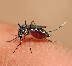
The Municipal Corporation of Guragon is using drones and GIS to map areas prone to the deadly dengue virus, spread by mosquitos, the Times of India reports. The map provides the government with information about where standing water is likely to be a problem, based on known drainage issues. That data is combined with information about where cases of dengue have broken out and the efforts taken as preventative measures, such as fogging operations.
Dengue is a debilitating and potentially fatal tropical disease carried by mosquitos; it is prevalent in the tropics across the globe. Thus far, there have been over 20 cases of dengue reported in Guragon this year. “We started the project some 10 days back. So far, we have gathered data of 80 places that are waterlogged. We are also keeping a close check over locations from where cases of dengue are being reported. The step will not only help in preventing and controlling dengue this year, but we will have enough database and analytics to deal with the disease in coming years too,” MCG commissioner TL Satyaprakash told the Times of India.
While many of the areas – about 70% – with drainage issues, providing a breeding ground for mosquitos, are in “unplanned” areas of the city the drone surveys have shown that the problem is not isolated to poorer areas. Drone footage shows uncovered water tanks on the roofs of many of the areas wealthier homes.
The agency is overlaying data about reported cases of the disease with the aerial footage to target response. The MCG is crowdsourcing data via an online survey to add even more data to the project. The “Storm Drainage Questionnaire” asks people to identify locations where water has pooled after storms or where flooding has occurred.
The data will allow the health department of Guragon to understand the dengue trend year over year; they intend to conduct a door-to-door campaign to spread awareness and to carry out inspections and fogging operations. The project could serve as a model for other areas fighting mosquito-borne diseases.
Source link


