 An Arizona-based startup is equipping a local police department with a unique air-traffic control system for its future drone fleet.
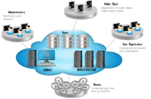
Drone Control Systems recently signed an agreement with the Sahuarita Police Department to deploy the company’s Local Area Drone Dispatch and Authorization System software and hardware solution.
“[LADDAS] provides near real-time data via private and secure cloud services to ensure administrators are fully aware of where their UAVs are operating while providing a detailed understanding of the type of operations that are currently being exercised,” a DCS press release stated.
The police department will be able to monitor, track and manage any of local drones it in the field and send pilots notifications from a command center.
The company is training officers and assisting the agency with the FAA authorization process ahead of plans to deploy an unspecified number of police drones. Like a growing number of police departments, SPD plans to use drones to investigate crime scenes, conduct search-and-rescue operations and monitor traffic accidents.
“When they explained to me all the things that LADDAS could do, I was on board. When drone operators use LADDAS, it educates them, and helps them comply with the law,” Sahuarita Chief of Police John Noland said.
“If drone users comply with the law, then it takes less department resources to address community concerns about drones. LADDAS will save our department money by decreasing investigative time required to address community drone issues,” he added.
“LADDAS is a low cost, high value system,” Drone Control Systems President James Lawrence said in a statement.
“We predict that the pilot program will show maximized use of tax dollars by allowing for more efficient use of police officers’ time and other department resources, while effectively maximizing the safety, of not only the community, but those guarding its’ safety as well.”
Lawrence added that LADDAS will allow users to register in the system, “associate FAA drone registration with LADDAS registration; alert drone operators to the proximity of other drones; monitor and record, and play back drone flight activities; send directions to guide personnel to the UAV’s current location and create permissible drone flight areas and no- fly zones,” among other uses.
The system uses proprietary drone-mounted transponders transmitting GPS data to the LADDAS framework. Drone operators can interface via a mobile app.
Source link


