The idea of a drone superhighway may sound like a concept from the latest science fiction blockbuster.
But it could soon become a reality in England, with the submission of plans to build a network across the Midlands and the Southeast.
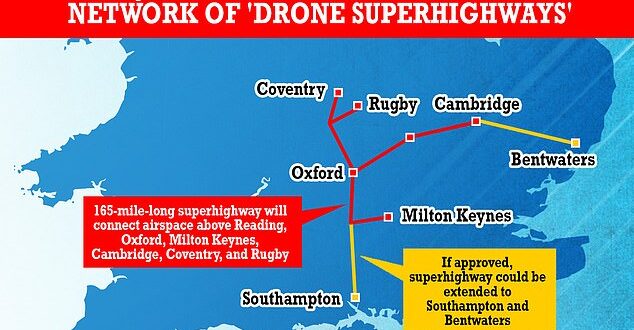
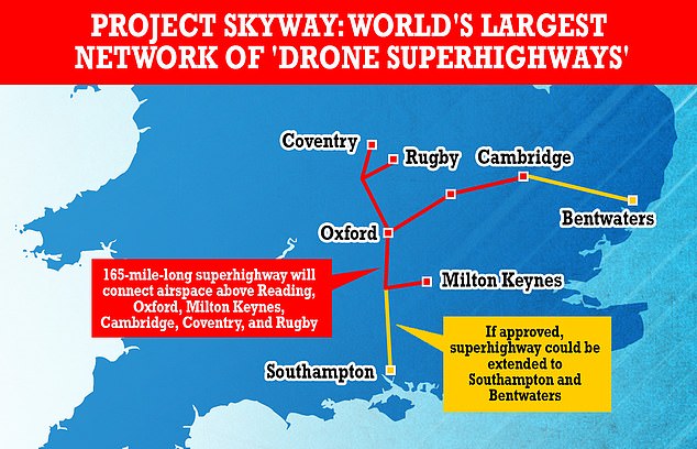
A consortium led by software provider Altitude Angel has submitted plans for a 165-mile-long superhighway network dubbed Project Skyway, connecting airspace above cities including Reading, Oxford, Milton Keynes, Cambridge, Coventry, and Rugby.
If approved, the network could potentially then be extended to Southampton on the south coast and Ipswich on the east coast.
The group hopes the superhighway will ‘unlock the huge potential offered by unmanned aerial vehicles,’ with a decision from the government on whether to green light the project expected in the coming weeks.
A consortium led by software provider Altitude Angel has submitted plans for a 165-mile-long superhighway network dubbed Project Skyway, connecting airspace above cities including Reading, Oxford, Milton Keynes, Cambridge, Coventry, and Rugby
The group hopes the superhighway will ‘unlock the huge potential offered by unmanned aerial vehicles,’ with a decision on whether to green light the project expected in the coming weeks
‘This is the most ambitious transport project proposed for the country since the advent of the railway network in the 18th century,’ said Richard Parker, CEO and founder of Altitude Angel.
‘Britain is at the forefront of a second transport revolution.
‘Drones have the potential to transport goods in a way our ancestors could never have imagined but would have surely understood.
‘Britain can lead the world in these innovative and life-saving technologies, we have the skills and ambition to open our skies to safe and secure drone and air-taxi flights.’
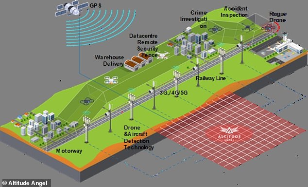
To cover the 165 miles of superhighway, Altitude Angel will need 29 Arrow Towers – the technology which allows the flights to operate safe and securely in unrestricted airspace.
Existing infrastructure, such as phone masts, will be utilised where possible, a spokesperson told MailOnline.
The drone superhighway will use Altitude Angel’s detect and avoid (DAA) technology to prevent collisions between the flying vehicles.
This technology was developed back in 2020 and tested in a five-mile flight corridor just south of Reading.
To cover the 165 miles of superhighway, Altitude Angel willl need 29 Arrow Towers – the technology which allows the flights to operate safely and securely in unrestricted airspace
It feeds automated instructions to the unmanned drones to keep them away from others or change path if they’re in danger of crashing.
According to Altitude Angel, DAA only requires basic technical integrations and does not require specialist hardware on-board the drone, meaning it can be utilised by a range of businesses.
When, or if, the project is approved by the government, the first superhighway will be set up across the Midlands and Southeast.
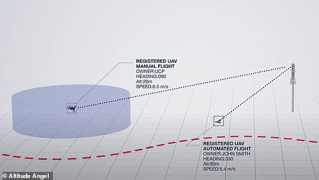
The drone superhighway will use Altitude Angel’s detect and avoid (DAA) technology to prevent collisions between the flying vehicles. It feeds automated instructions to the unmanned drones to keep them away from others or change path if they’re in danger of crashing
If that proves a success, Altitude Angel says it will make the technology available to allow other towns and cities around the world to set up their own drone superhighways.
‘With the government’s support, using this technology as its foundation, we can create networks spanning the length and breadth of Britain, a super-highway-network-in-the-sky, providing a critical digital infrastructure which will, in-turn, enable the world’s first truly national drone economy,’ Mr Parker added.
It remains unclear how much the network will cost to be set up, should it be approved.
HOW CLOSE IS A NEAR MISS BETWEEN AIRCRAFT AND DRONES?
Near miss is a common term used to describe encounters between different airborne vehicles.
Governed by Airprox, there is no specific distance stated, instead it is gauged by the opinions of the pilot, air traffic controller and the drone operator.
Earlier this year a ‘near-miss’ report was filed between a police drone and two fighter jets travelling at 520 mph.
Governed by Airprox, there is no specific distance stated, instead it is gauged by the opinions of the pilot, air traffic controller and the drone operator
The Devon and Cornwall officer was convinced there would be a collision as the military jet came into view.
The Airprox board reported the 13lbs device was flying at an altitude of around 300ft when the pilot heard a fast jet approaching.
The F-15 pilot, who was flying at an altitude of 500ft, could not see the drone but the drone pilot said the risk of a collision was ‘high’.


