With mining industries growing in scale and competitiveness, companies are digging into drone tech to unearth any advantage available – and it seems to be working.
 In South Africa, drone deployment in area mines is on the rise as companies view UAVs as a way to restructure their cost models. According to South Africa’s IT Web, mining companies use drones for “everything ranging from mapping to mineral exploration to tracking stockpiles.”
UAV Industries chief flight instructor Gregory Donaldson tells IT Web that mining adoption of drones is on pace to grow faster than in any other sector:
“Since the regulations were introduced in July last year, drones quickly became popular within the film and entertainment industry, this was followed by the agricultural sector, although these two sectors indicate the highest numbers in drone adaptation, however the fastest growth we’re observing at the moment is from the mining sector. They use the drones to fly over an area of heaped coal, sand and other resources used in the mines, the cameras are used to view the stock pile for stock measurement.”
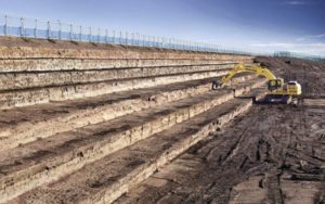
Mining companies across the globe are seeing valuable results from drone use. Last year, Rio Tinto, one of Australia’s largest mining and metal companies, “struck gold” after deploying drones – or at least a gold rush of data.
The mining giant launched drones to monitor its coal and iron ore facilities in Western Australia and Queensland. Deploying a combination of fixed-wing and rotary UAVs equipped with video, infrared and other sensor arrays, the company can survey stockpile inventory, perform remote survey work, monitor wall movements in mines and inspect various infrastructure lines.
In 2015, Japanese equipment manufacturer Komatsu announced a partnership with Skycatch, a provider of commercial drone data solutions for mining companies as well as within construction and energy industries.
The service, which goes by the name Smartconstruction, uses drones to create a detailed three-dimensional site map which is compared to a blueprint to determine how much earth needs to be moved in a mining or construction project. Komatsu machinery equipped with information and communications technology reads the data and automatically digs at the correct angles.
Source link


