Dr. Christophe Cleguer is on a mission to save the dugong. In doing so, he’s saving a critical habitat for a host of other marine species.
Dr. Cleguer has spent many career hours keeping a watchful eye on the dugong, the world’s only herbivorous marine mammal which is found in the Indian and western Pacific Oceans.
These enormous vegetarians spend their days casually munching seagrass meadows, keeping crucial ocean ecosystems in balance for a raft of other sea life.
The species acts as a bellwether for the overall ecosystem—seagrass meadows with dugongs are healthy. And when areas of seagrass are healthy, they provide a habitat for other sea life and play an important role in sustaining clean seawater and safeguarding coasts from erosion.
But these big creatures, commonly referred to as “sea cows,” can be difficult to find and research by boat so a higher vantage point is required to locate, track and study them.
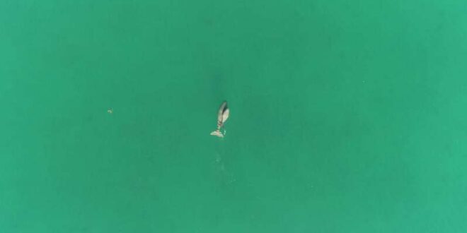
Looking down from above
As part of Dr. Cleguer’s research, unmanned aerial vehicles, or drones, are being used to survey and assess dugongs and their habitats. The vast amount of data generated by these aerial surveys is making a significant impact on the way dugong conservation and management is undertaken.
“The use of drones in marine research has many advantages and opportunities. In addition to being much safer for scientists, cost effective and having a reduced carbon footprint, the data collected by drone is more accurate, including the ability to pinpoint the location of the animal more effectively,” said Dr. Cleguer.
On average, a three-week research trip can involve 90 aerial survey flights and generate approximately 25,000 images. This comprehensive level of detail is difficult to achieve by other means.
“Over the past three years, we have developed a new methodology around the use of small and mid-size drones in marine research including survey design, data collection and processing as well as the analysis of data. The exciting outcome is that we are starting to develop some detailed maps around dugong population numbers and density. We hope that the research work using this new technology will fast-track the conservation of dugongs and their seagrass habitats,” explained Dr. Cleguer.
Empowering community conservation
“One of the goals of my research is to empower communities to manage their own conservation and marine management efforts and use drone methods that have been developed in order to learn how to protect their own local dugong populations and habitats.”
Dr. Cleguer is working with Murdoch University Research Fellow, Dr. Amanda Hodgson, on expanding the use of these smaller and cheaper drones in developing countries. The focus is on places where dugong populations are prevalent to help communities build capacity in their local conservation efforts.
“Our use of smaller drones and developing new tracking tools and techniques for dugong conservation is in the hope of putting conservation back in the community’s hands and to all play a part in the survival of the dugong species.”
While most of his initial research and development work took place on the Pilbara region of Western Australia, Dr. Cleguer is now involved in projects using drone technology in Europe, Southeast Asia and Melanesia.
Both researchers are involved in the recently started Seagrass Ecosystem Services Project funded by the International Climate Initiative and administered and implemented by the Convention on Migratory Species. The goal of this project is to improve conservation of seagrass meadows and the biodiversity they support in Indonesia, Malaysia, the Philippines, Thailand, and Timor-Leste.

Tracking dugongs at night
The team’s aerial surveys are complemented by tracking using telemetry tools that enable them to develop a broader understanding of the animals’ use of space and behavior.
For example, Dr. Cleguer uses GPS-satellite and accelerometry tags on dugongs to track and understand how the animals move at night, as drones are only able to fly in the day time. The use of accelerometry tags on dugongs in New Caledonia in 2019 was a world first in the research of dugongs in the wild.
“By using various technology at our disposal, we really start to build a story and a deeper understanding of dugongs—when they feed, rest, their movements and of course, their critical habitats. Through our data, we have already started drawing important linkages between dugong presence and seagrass habitats,” explained Dr. Cleguer.
“We are continually building upon our knowledge of the dugong’s spatial ecology, and with the data and information we have, we will be able to help communities understand the extent of conservation efforts required to ensure dugong survival.”
Innovative drone conservation research shared internationally
Murdoch University
Citation:
Drones driving community conservation of the sea cow (2020, August 14)
retrieved 14 August 2020
from https://phys.org/news/2020-08-drones-sea-cow.html
This document is subject to copyright. Apart from any fair dealing for the purpose of private study or research, no
part may be reproduced without the written permission. The content is provided for information purposes only.


