Guest Post: This article published with permission from our partners at DroneII, Drone Industry Insights. Article authored by Lukas Schroth.
In our previous article (Drones and Artificial Intelligence) we discussed the principles of intelligent data processing for drones, in order to introduce you to the links between drones and artificial intelligence.
One of the most important goals of AI in the drone industry is to make efficient use of large data sets which are collected by the drone – this would mean the datasets were addressed in an automated way without a human in the loop.
With the increasing development and spread of drone technology, the availability of high-resolution images used for various tasks such as maintenance, surveying, mapping and monitoring is increasing. There are already many established software companies on the market offering intelligent data analysis solutions to make unstructured drone data “actionable” and gain meaningful insights without time-consuming manual analytics.
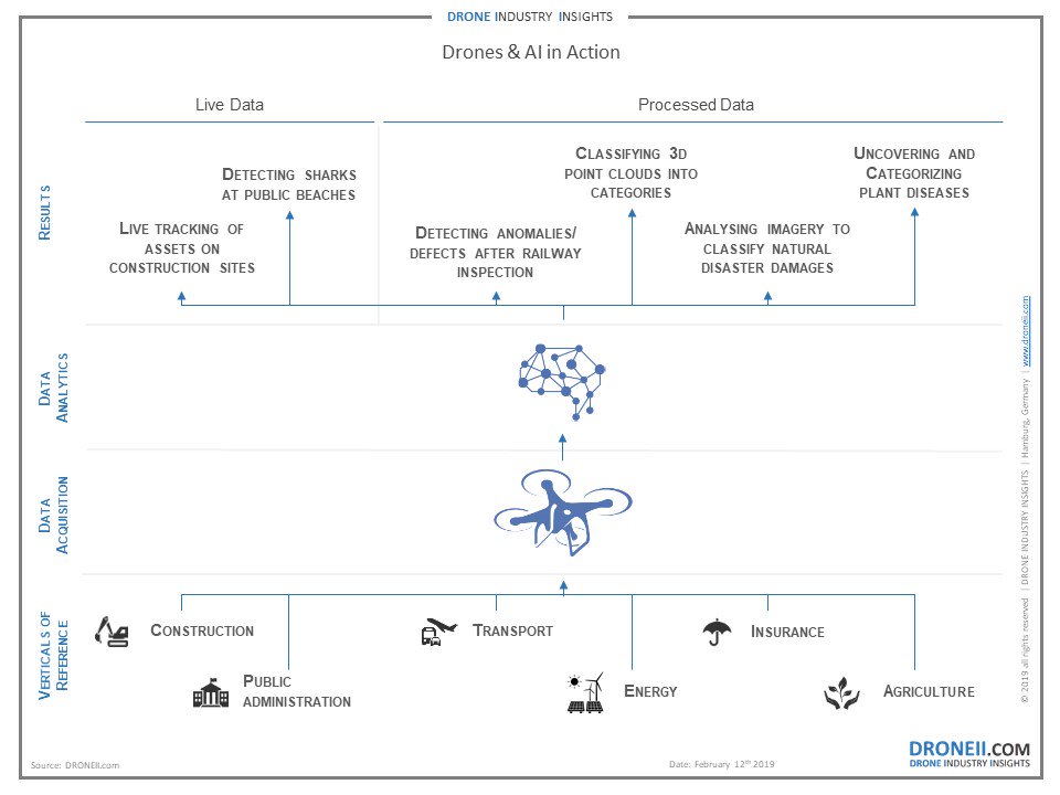
Counting Cars and Tracking Sharks: Intelligent Data Analytics in Practice
The use of deep learning and/or machine learning algorithms already ranges across many verticals prominent in the drone industry – starting from agriculture all the way to safety & security.
For example, at the end of 2017 Pix4D had already started using machine learning algorithms for several photogrammetry applications to classify 3D point clouds into categories like buildings, roads or vegetation. Various intelligent tools for counting trees and determining their height and type are now available. One can even use these tools determine the total road, building, or vegetation surface, counting cars in a parking lot, or roofs that are suitable for solar cell coverage in a region of interest.
Pix4D also collaborated with Hummingbird to develop a software to help farm managers and agronomists tackle problems with crop and plant diseases which cause major disruptions in their productivity. They added specific machine learning features to robust algorithms to uncover and decipher hidden patterns, which helps their customers achieve more accurate diagnosis and targeted treatments.
Ardenna is utilizing image processing and artificial intelligence to automate the detection, classification and reporting of anomalies found during railway and wind turbine inspections. After a railway inspection conducted by a drone collects roughly 40,000 images from 100 miles of rails, their software can detect 30 different types of anomalies automatically taking less than 5 hours to process.
In an automated mission, Skycatch’s system can identify and track assets and material deliveries across an active construction site using deep learning models. Live tracking like this can anticipate delays and, over time, learn how to prevent them saving the construction companies a lot of money.
EagleView Technologies already used machine learning algorithms to create property analytics data after hurricane Harvey already in 2017. This approach allowed insurance carriers to analyze drone images and classify damages efficiently, which is extremely important to close vast amounts of claims rapidly in post-hurricane scenarios.
The Australia-based Westpac Group is offering Shark Spotter, a system that uses drones equipped with object recognition to detect signs of sharks in the water. The team developed the algorithm based on a sophisticated deep-learning framework that serves as the backbone for the shark detection and recognition system in real time.
The US-based platform, Nanonets, supports other companies or software developers in building machine learning models. They are trying to increase the number of people who can utilize machine learning by making adoption easier. All clients need to do is send them a few samples so that the model can learn from it, e.g. to inspect solar plants or to count objects of interest in an image.
Nearthlab, a Korean software company, is currently working on a solution that automatically detects and reports damages on wind turbine blades out of the photos. Once this this technology is applied, damages can be identified quickly, and additional measures can be initiated if needed.
Survey Results: Drone Data Analytics Manufacturers Across Verticals
To produce this article, we recently conducted a survey to get a snapshot of market players in different verticals within the industry. The map below shows the companies (ordered alphabetically) who participated in our survey and the industries in which they are active.
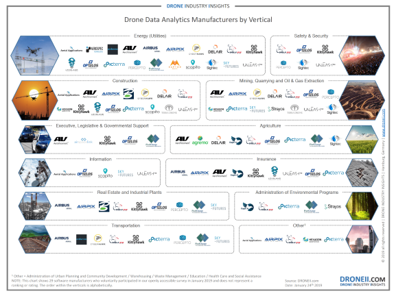
Most companies polled are dedicated to manufacturing drone software for data analytics for the energy sector. Many of them stated that they use data analytics software not only to visualize industrial assets, but also to identify and manage issues or anomalies for maintenance. The second most named industry was construction. Most applications here involved monitoring changes in construction sites or measuring the volume of stockpiles. Software developers in mining, quarrying and oil & gas extraction created software tools to: monitor the site progress, map data of an entire mining site, or measure extracted volumes.
 The survey also shows that 37% of the respondents are using solely artificial intelligence algorithms whereas 63% still trust in traditional computer vision software in combination with machine learning or deep learning approaches. None of the drone data analytics manufacturers stated that they do use neither machine learning or deep learning algorithms. Within the companies which are solely using AI driven software, 50% take advantage of both deep learning and machine learning. 30% work with only machine learning algorithms, while already 20% utilize only deep learning.
What’s Next?
As already mentioned in our previous post, artificial intelligence is not the solution for all big data analysis questions yet. AI techniques (machine learning or deep learning) and their results are only as good as the training data used to build the classification models.
Most drone data analytics companies are still using traditional methods to process data acquired from drones. But the fact that all participants responded positively to the question of whether they deploy artificial intelligence tools or not shows again that AI seems to be increasingly essential to them. 37% off the respondents already completely rely on machine or deep learning and all signs indicate that this will increase as time goes on.
Further utilization and development of these powerful intelligent data processing tools will help greatly reduce the processing time of big data, which is a huge challenge today. Data analytics software is now being deployed within a diverse set of drone applications in all relevant industrial sectors. Unsurprisingly, there are more software developers working in the more mature industries (energy, construction, and mining & quarrying) than in others. However, this is not to say that smaller and less wealthy industries are devoid of analytical software tools. Insurance, agriculture, real estate and transportation are all sectors which are increasingly seeking and gaining access to analytical software.
While this article focused on the analysis of acquired data, the other way in which AI plays a role in drone technology is through motion planning – i.e. influencing the behavior of the UAV platform. We are already witnessing advances such as Skydio’s self-driving drone, yet as AI applications in the drone industry are gaining importance highly automated flights will become more feasible and more common.
Miriam McNabb is the Editor-in-Chief of DRONELIFE and CEO of JobForDrones, a professional drone services marketplace, and a fascinated observer of the emerging drone industry and the regulatory environment for drones. Miriam has a degree from the University of Chicago and over 20 years of experience in high tech sales and marketing for new technologies.
Email Miriam
TWITTER:@spaldingbarker
Subscribe to DroneLife here.
https://dronelife.com/2019/02/13/droneii-drones-and-ai-2-0/


