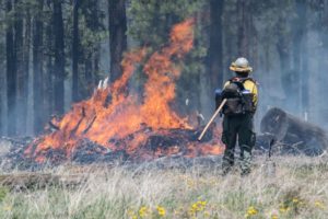
Photo courtesy of Arizona State Forestry
Safety officials across the country continue to warn drone users “Don’t fly aircraft over wildfires.”
This week, Arizona State Forestry officials spotted a drone over the Coldwater fire – a blaze that has burned more than 6,000 acres of the Coconino National Forest since being sparked by a lightning strike on May 30.
On Saturday, a flight coordinator saw a drone flying over the Temporary Flight Restriction area, forcing a firefighting helicopter to be grounded for safety reasons.
“This is a huge safety issue, folks,” Arizona State Forestry wrote on Twitter on Sunday. “When a drone is spotted, aviation being used to help suppress a fire has to be grounded.”
“It is illegal to operate a private drone near any wildfire,” a forestry official stated. “Drones near wildfires create a serious safety hazard for fire aircraft and result in aircraft being grounded immediately.
On the positive side, firefighters are using authorized UAVs to drop small detonation devices for ignitions during burnout operations in places hard to ignite by hand and it also flew reconnaissance missions. The fire is located about four miles south of Clints Well, within one mile east of state Route 87.
Drones have been used by many agencies to aid in wildfire mitigation efforts.
Last year, California Air National Guard‘s 195th Airlift Wing launched a drone reconnaissance mission to aid firefighting efforts in northern California. The unit deploys a MQ-9 Reaper drone to monitor and track wild fires. The drone flights collect data, imagery and telemetry which is transmitted to state firefighting officials.
In 2017, Boeing subsidiary Insitu coordinated with analytics firm Esri to complete drone test flights to support firefighting efforts. Insitu deployed its INEXA Solutions aerial remote sensing teams to aid firefighters in suppressing the Eagle Creek fire in Oregon. The platform includes a suite of INEXA capabilities such as ground-based command and control, manned and unmanned air vehicles including ScanEagle, and sensors and analytics to provide custom solutions and answers to mitigate business challenges from seabed to space.
Jason is a longstanding contributor to DroneLife with an avid interest in all things tech. He focuses on anti-drone technologies and the public safety sector; police, fire, and search and rescue.
Beginning his career as a journalist in 1996, Jason has since written and edited thousands of engaging news articles, blog posts, press releases and online content.
Email Jason
TWITTER:@JasonPReagan
Subscribe to DroneLife here.
https://dronelife.com/2019/06/12/drone-spotted-over-arizona-wildfire-forcing-setback/


