3:42 pm
ANAFI 4G, Drone, drone mapping, Drone News Feeds, Feature 1, GIS, Logiroad, mapping with drones, News, Parrot, Parrot drones, Positano
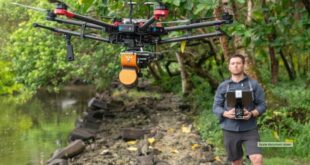
Parrot, Logiroad complete ‘impossible’ drone mapping mission over Positano By Jim Magill The Italian town of Positano, which hugs the cliffs along Italy’s scenic Amalfi Coast, is a delight for tourists and fashion lovers, and a nightmare for mapmakers. The city’s topography, with streets that wind along the hills and …
Read More »
7:55 pm
commercial drone software, Drone, drone mapping, drone mapping in Tokyo, Drone News Feeds, News, Pix4D
Photogrammetry platform provider Pix4D continues their global growth, expanding their Tokyo office to serve the Asia Pacific (APAC) region. The expansion demonstrates growing demand in the region for software solutions to support commercial drone operations. Swiss-based Pix4D, a Parrot company, already has offices in Lausanne, Berlin, Madrid, San Francisco, Denver, …
Read More »
1:53 pm
Drone, drone mapping, Drone News Feeds, LIDAR, News, philippe simard, SimActive
Canadian mapping platform SimActive has added some significant new capabilities this year, including colorized point clouds and reflective calibration. CEO Philippe Simard explains what these features are – and how clients are using them. SimActive releases new features regularly. “With our user base growing exponentially, we are constantly monitoring how our …
Read More »
9:17 am
Drone, drone GIS, drone LiDAR, drone mapping, Drone News Feeds, drones for archeology, drones for architecture, Feature 1, News, Visualskies
By DRONELIFE Staff Writer Jim Magill Using drones, 3D scanning technology, LIDAR and other state-of-the-art technology for measuring, interpreting and visualizing data, a UK-based company has done everything from uncovering lost civilizations to creating augmented reality for movies and television. Founded in 2014, Visualskies has grown from a company narrowly …
Read More »
4:28 pm
Drone, drone industry funding, drone industry investment, drone mapping, Drone News Feeds, DroneDeploy, News
A new round of DroneDeploy funding adds $50 million to the company, bringing the total to date to $142 million: which a company release says is the most to date for any drone data company. This latest Series E funding round is the result of DroneDeploy’s explosive growth (they report …
Read More »
6:38 pm
Drone, drone data, drone LiDAR, drone mapping, Drone News Feeds, drone photogrammetry, LIDAR, News, photogrammetry, SimActive
Drone-based mapping and LiDAR are a powerful combination. Now, Canada’s SimActive Inc., a leading developer of photogrammetry software that can accommodate aerial imagery from satellite, manned aircraft, or drones, announces the integration of its Correlator3D™ product into LiDAR systems for drones developed by LiDAR USA. LiDARUSA, also known as Fagerman Technologies, …
Read More »
7:47 pm
correlator3d, Drone, drone mapping, Drone News Feeds, photogrammetry, SimActive
SimActive‘s new version of Correlator 3D, version 8.6, is feature-rich – making mapping from aerial images easier and more accurate all the time. Canada’s SimActive is a photogrammetry software that began as a solution for aerial images from satellite and manned aircraft. The inclusion of drone data in the solution …
Read More »
7:20 pm
ANAFI USA, Drone, drone manufacturers, drone mapping, Drone News Feeds, News, Parrot, Pix4D
Parrot, the leading European drone group, and Pix4D, the leading professional photogrammetry and drone mapping software company, “are excited to announce the latest generation ANAFI USA drone is now compatible with the Pix4D software suite,” says a Parrot press release. That’s not a surprise, as Parrot owns 95% of Pix4D. …
Read More »
6:07 pm
Applications, Construction, Drone, drone mapping, Drone News Feeds, DroneDeploy, DroneDeploy conference, Mike Winn, News, photogrammetry
At this week’s DroneDeploy conference, DroneDeploy co-founder Mike Winn says that despite the challenges of 2020, the future of drone mapping, and the drone community, is here. In an opening address, Winn presented a fascinating view of the worksite of the future, using the construction industry as an example. “Almost …
Read More »
1:09 pm
Australia bushfires, Drone, drone deploy.org, drone mapping, Drone News Feeds, DroneDeploy, DroneDeploy.org, Fire and Police, News, Team Rubicon
Drones and mapping go hand in hand: the aerial imagery captured by drones provides a new way of creating accurate maps and models of areas both large and small. DroneDeploy has been at the forefront of drone mapping since 2013. It’s founders have always done what they could to help …
Read More »