5:33 pm
Drone, drone mapping, DroneDeploy, drones in AI, Mike Winn, News
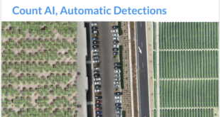
image: DroneDeploy Day 2 of the DroneDeploy Conference in San Francisco kicked off yesterday with a keynote address from co-founders CEO Mike Winn, Jono Millin and Nick Pilkington. DroneDeploy is announcing major new functionality for the platform. DroneDeploy, the world’s leading drone mapping platform, has had another phenomenal year of …
Read More »
2:29 am
Commercial Drones, Drone, drone conferences, drone mapping, Drone News Feeds, Drone Software, DroneDeploy, MapEngine, News
DroneDeploy‘s annual user conference opened today in San Francisco; and in addition to training opportunities, partner demonstrations, and a lot of face time with other drone professionals;, the company is offering a closer look at the technology behind their industry-leading platform. DroneDeploy co-founder Jono Millin said in his opening remarks …
Read More »
10:09 am
Alietum Ltd., commercial drone software., Correlator 3D, Drone, drone mapping, Drone News Feeds, drones in mining, Featured - Mining, mining drones, News, photogrammetry, SimActive
SimActive Inc. is a world-leading developer of photogrammetry software – for drones and for manned aircraft. It’s a professional tool that provides the speed and precision big business expects. SimActive’s Correlator 3D software takes data from any sensor and uses one software interface for processing. Now, SimActive introduces new features …
Read More »
9:52 pm
3DN, Agriculture Drones, cloud-based drone mapping, Drone, drone mapping, Drone News Feeds, drone platform, DroneDeploy, Featured, Map Engine, News
In October of 2017, we published a story about DroneDeploy‘s huge growth: “In just this year, the company has mapped more than 25 million acres, representing an area larger than the country of Iceland. They’ve processed 40 million images in 2017, create thousands of maps every day, and have processed …
Read More »
2:26 pm
Business and Finance, Commercial Drones, Drone, drone mapping, Drone News Feeds, DroneDeploy, drones in AI, drones in construction, Feature 1, industrial drones, News
San Francisco-based drone mapping platform DroneDeploy simply scored one other $25 million in funding. Here’s why that’s not shocking. This week I had a dialog with an funding banker, who talked about casually that the VC urge for food for drone firms had diminished in the final yr. With the …
Read More »
9:54 pm
3D modeling, Agriculture Drones, commercial drone applications, Drone, drone mapping, Drone News Feeds, DroneDeploy, drones in agriculture, Feature 1, Featured - Agriculture, industrial drone applications, News
Drone expertise is evolving at an unimaginable tempo today, however few new bulletins actually supply a extremely game-changing – or work altering – characteristic. This one is totally different. A couple of years in the past, the flexibility to create a map from drone knowledge in actual time would have …
Read More »
12:28 pm
Commercial Drones, DART drones, Drone, drone mapping, drone operators, Drone Training, DroneDeploy, News
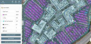
Image courtesy of DroneDeploy Operators hoping to develop their profession choices and shopper choices ought to head out to San Francisco on the finish of this month to make the most of DroneDeploy’s annual person convention, adopted by an intensive two-day workshop on aerial mapping with coaching consultants DARTDrones. DroneDeploy …
Read More »
10:35 pm
Drone, drone mapping, drones in Africa, eBee, INTERGEO, News, senseFly, Zanzibar
senseFly, the Swiss-based producer of the eBee and main producer of mapping drones, is launching a brand new line of industry-specific options at INTERGEO 2017 in Berlin subsequent week. senseFly’s new 360 options are “designed to boost the efficiency of survey and mapping teams,” the corporate says. The new options …
Read More »
12:17 am
Commercial Drones, Drone, Drone Apps, drone mapping, DroneDeploy, EZRoof, GCP Volume Analysis, News, Sponsored Content
The TensorFlight App from the DroneDeploy App Market As the trade grows and extra companies understand the advantage of drone expertise, profitable skilled operators and enterprises are scaling operations – and that’s not all the time straightforward. Expanding an enterprise stage drone program means assembly excessive requirements for operations and …
Read More »
11:55 am
Agriculture Drones, Business and Finance, Commercial Drones, DJI, Drone, drone mapping, DroneDeploy, News, Sentera, SLANTRANGE
DroneDeploy pronounces new options, permitting growers to make use of their trade main drone mapping platform with agriculture particular sensors, together with SLANTRANGE calibrated multi-spectral sensors and Sentera’s close to infrared sensors. “We’ve listened to our customers’ requests and worked with leading technology partners in the industry to help growers detect crop variability …
Read More »