 Aurigo Software, University of Florida Partner for New Underwater Surveying Drone System
by DRONELIFE Staff Writer Ian M. Crosby
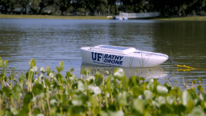
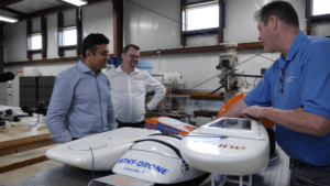
Capital planning and construction management software leader Aurigo Software has announced a partnership with the University of Florida’s Department of Mechanical and Aerospace Engineering for the development of Bathydrone, a new system for underwater surveying, mapping, and inspection.
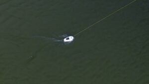
Currently, collecting data for underwater construction or inspecting existing assets involves manual surveying or boat-mounted survey sensors. The Bathydrone system deploys a drone carrying a small vessel equipped with a COTS sonar unit, removing the need for manual surveying. The sonar unit features down-scan, side-scan, and chirp capabilities and logs data within the hull’s onboard console, which can be retrieved post-mission and plotted in various ways.
 “We are excited to be working on this groundbreaking technology with the team at the University of Florida,” said Aurigo Software CEO and founder Balaji Sreenivasan. “The Bathydrone system will vastly expand the possibilities for underwater endeavors while providing a cheaper, safer, and more eco-friendly alternative for our customers.”
Bathydrone can be operated remotely and autonomously through AI navigation software, resulting in a faster and more affordable solution. By integrating with Aurigo’s Masterworks Cloud Platform, it will be able to organize project data and route inspections and other results for approval or further action.
 The compact and lightweight Bathydrone is fully battery-operated and environmentally friendly, and does not require a dock or boat ramp to get in the water. It can be deployed in a wide range of water systems, including shallow water and rivers with strong currents, and is capable of surveying a large area on a single charge
“This project supports our department’s mission to conduct state-of-the-art research to advance science and technology,” said Peter Ijfu, University of Florida’s Mechanical and Aerospace Engineering Excellence Term Professor and Associate Chair of Faculty Affairs. “This pioneering approach to underwater surveying and mapping has multiple real-world applications that are not currently commercially available.”
Aurigo will collaborate with the Department of Mechanical and Aerospace Engineering’s staff and students to deliver the solution to the infrastructure market within the next 12 to 18 months.
Read more:
Ian attended Dominican University of California, where he received a BA in English in 2019. With a lifelong passion for writing and storytelling and a keen interest in technology, he is now contributing to DroneLife as a staff writer.
Miriam McNabb is the Editor-in-Chief of DRONELIFE and CEO of JobForDrones, a professional drone services marketplace, and a fascinated observer of the emerging drone industry and the regulatory environment for drones. Miriam has penned over 3,000 articles focused on the commercial drone space and is an international speaker and recognized figure in the industry. Miriam has a degree from the University of Chicago and over 20 years of experience in high tech sales and marketing for new technologies.
For drone industry consulting or writing, Email Miriam.
TWITTER:@spaldingbarker
Subscribe to DroneLife here.
https://dronelife.com/2023/06/07/bathydrone-aurigo-software-university-of-florida-develop-underwater-surveying-drone-system/


