8:41 am
DJI, Drone, Drone News Feeds, Feature 1, motorcycle drone, Ural
Here at DRONELIFE we’re a typical tech company – we’re often multitasking by combining caffeine consumption and writing. In a recent coffee shop, we just had to engage with a couple who arrived on our absolute dream: a gorgeous Ural motorcycle, complete with gleaming sidecar. Life goals – but that …
Read More »
8:39 pm
DJI, Drone, Drone News, Drone News Feeds, News, Robomaster, Technology
Drone-industry leader DJI is launching its fifth international robotics competition and engineers from around the word are all invited to compete for more than $100,000 in cash prizes. The fifth annual RoboMaster Competition is open to all universities and students with a passion for engineering and technology. “What’s unique about …
Read More »
4:37 pm
airspace security, Commercial Drones, DJI, Drone, LATAS, News, PrecisionHawk, UTM
The following is press release from PrecisionHawk. PrecisionHawk’s Low Altitude Traffic and Airspace Safety (LATAS) platform to replace AirMap PrecisionHawk, Inc. today announced a partnership with DJI, the world’s leader in civilian drones and aerial imaging technology, to improve its geofencing technology. Leveraging PrecisionHawk’s Low Altitude Traffic and Airspace Safety …
Read More »
12:37 pm
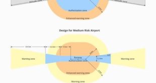
AirMap, DJI, Drone, Drone News Feeds, Feature 1, GEO, geospatial data, News, PrecisionHawk
DJI has announced improvements to its geofencing technology. The move will refine airspace limitations for drone flights near airports to provide better protection to airplanes in sensitive areas. The GEO update will be backed by geospatial data from PrecisionHawk, replacing Airmap, the Santa Monica-based company DJI had been working with since …
Read More »
2:42 pm
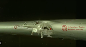
CNN, Commercial Drones, DJI, Drone, Drone Crash, Drone News Feeds, Feature 1, News, University of Dayton
News and Commentary. The University of Dayton Research Institute recently released a video showing that when a Phantom 2 quadcopter hits the wing of an aircraft directly, bad things happen. The internet and news media, unsurprisingly, have gone to town: “Devastating Damage,” “Serious Damage,” and “Growing Risk” are all part …
Read More »
8:36 am
Commercial Drones, DJI, Drone, Drone News Feeds, Feature 1, industrial drones, News, Phantom 4 RTK, surveying drones
DRONELIFE was present this morning when DJI announced the global launch of the Phantom 4 RTK mapping and survey drone. The launch shows DJI’s continued commitment to the commercial market, where they already hold the major market share with the customer favorite Phantom 4, and the new Mavic Pro series. …
Read More »
10:10 am
DJI, dji mavic air infographic, dji mavic air mavic pro comparison, dji mavic air specs, Drone, first flight, head to head, mavic air, Mavic Pro, News, review, Reviews, sample video, side by side, test footage, thoughts, unboxing
3 Comments Posted on July 8, 2018 I recently got the new DJI Mavic Air drone and did an unboxing/some first flight tests to show you guys how the footage and image quality looks (scroll down to the end of this post to download the 4K footage and a RAW …
Read More »
2:01 am
back market, Business and Finance, DJI, Drone, drone discounts, Drone News Feeds, Drones in the News, Enthusiasts, News, Products, refurbished drones
As drones get easier to fly and aerial photography from around the world continues to go viral, more and more people want in on the action. And that means more retailers are vying to be drone distribution points, too. As we’ve seen before with the likes of Fat Lama, plenty …
Read More »
12:06 am
Business and Finance, DJI, Drone, drone flight academy, Drone News Feeds, Europe, holland, Inspection, Netherlands, News, Products, training, training course, utc
DJI has launched a UTC (Unmanned Aerial Systems Training Center) program in the Netherlands. The move will provide businesses and commercial pilots in Europe with a place to train and learn how best to use drone technology for professional applications. The European UTC program will offer training in the classroom and …
Read More »
6:00 pm
aerial photography, Amazing Footage, DJI, Drone, Drone News Feeds, Drones in the News, Enthusiasts, News, Video, Yann Arthus-Bertrand
Drone manufacturer DJI has appointed French aerial photographer and film director Yann Arthus-Bertrand one of three DJI ‘Masters’. The French artist, whose work includes ‘The Earth From Above’ – a United Nations-supported collection of photo essays that has sold more than 4 million copies – has been using DJI equipment while shooting his …
Read More »