7:47 pm
Drone, Drone News, Drone News Feeds, Fixed wing, News, Sabrewing, VTOL
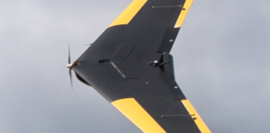
A California startup is launching its latest drone model with a boost of funding from VC firms. Along with Idaten Ventures and other firms, Japanese VC Drone Fund is investing more than $1.8 million in Camarillo-based Sabrewing Aircraft Company – a manufacturer of vertical-take-off-and-landing cargo drones. The Drone Fund and …
Read More »
5:57 pm
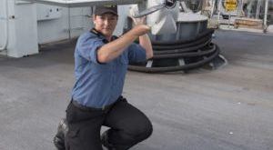
Aerovironment PUMA, Defense, Drone, Drone News, Drone News Feeds, Fixed wing, News, Royal Canadian Navy
The Royal Canadian Navy is sailing a new drone concept to serve as eyes and ears beyond a ship’s horizon. Kingston-class coastal defense ships will deploy Puma fixed-wing drones to provide beyond-visual-line-of-sight intelligence, surveillance and reconnaissance, a naval release stated. Manufactured by AeroVironment, the drone can stay aloft for two …
Read More »
3:36 am
Aerospace, astigan, Business and Finance, Drone, Drone News Feeds, Enthusiasts, Fixed wing, HAPS, Imaging, mapping, News, ordnance survey, solar power, Technology, UK
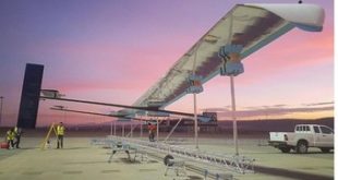
National mapping agency for Great Britain and leading geospatial data organization Ordnance Survey (OS) has announced plans to launch a solar-powered drone that will fly at high altitude to complement existing satellite mapping systems. The aim of the High Altitude Psuedo Satellite (HAPS) project, called Astigan, is to provide faster, higher quality images …
Read More »
9:07 am
Delair, Drone, Drone News, Drone News Feeds, Fixed wing, Fixed wing drones, News, Trimble
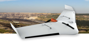
Commercial drone solution provider Delair this week announced the release of an new integration to its Trimble Business Center software. The integration enables geospatial professionals to drag and drop data from the Delair UX11 PPK drone system directly into Trimble Business Center projects. Users can combine high-quality flight data with other sensor …
Read More »
7:12 am
DL Exclusive, Drone, Drones doing good in Europe, Fixed wing, globehe, Healthcare, hemocue, Imaging, News, training, Transportation, UTM
One of the best things about life on the road is the opportunity to meet new companies and new people stretching the boundaries of what drones can do for communities around the world. At the recent Commercial UAV Show in London, DRONELIFE had the opportunity to meet Helena Samsioe, CEO …
Read More »
6:53 am
Drone, Drone News, Drone News Feeds, e2E, Fixed wing, News
e2E Satcom Limited, a provider of satellite communications solutions, has announced that it has successfully completed its first over-the-air flight test of the newly launched UAS-I SATCOM communication node for drone systems. The node is based on the company’s e2Eaccess technology that features low size, weight and power (SWaP) profiles. …
Read More »
12:52 pm
Agriculture, Delair, Drone, Drone News, Drone News Feeds, Fixed wing, News
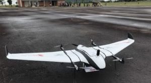
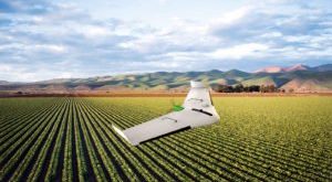
A French-based drone provider is planting new seeds it hopes will take root over farms around the world. Commercial drone solution provider Delair this week launched a new UAV model focused on the agriculture industry — the UX11-Ag. Built on the company’s current UX11 fixed-wing drone, the new version “combines the …
Read More »
4:48 pm
Business and Finance, commercial drone platform, Drone, Drone News Feeds, ebee x, Featured - Products, Fixed wing, Fixed-wing, Imaging, mapping, Mining and Aggregates, News, Parrot, senseFly, Technology
Amid the avalanche of product and service launches, partnership announcements and general industry news at Interdrone earlier this month, senseFly, a division of French drone manufacturer Parrot, unveiled a new modular drone for aerial mapping and surveying. On paper, the eBee X looks like a useful fixed-wing aircraft that should …
Read More »
3:54 am
ALTI, Drone, Drone News, Drone News Feeds, Fixed wing, News, VTOL
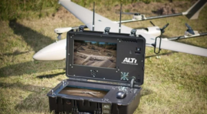
South Africa-based drone developer ALTI UAS recently launched a UAS Ground Control System for its Transition model drones as well as other systems. In a press release, ALTI describes the unit as “an advanced, modular, multi-link unmanned aircraft command and control system.” “It features everything from a high-quality intel computer, …
Read More »
12:52 pm
Andrew Duggan, Boeing, Business and Finance, Drone, Drone News Feeds, Fixed wing, Imaging, Insitu, LIDAR, Mining and Aggregates, News, photogrammetry, ScanEagle, Sensors
Boeing subsidiary Insitu has revealed that its latest advancements in High Accuracy Photogrammetry (HAP) are pushing the theoretical limits of aerial photography at altitude. Last month Insitu’s latest prototype carried a HAP payload that can capture images accurate to within five centimeters (cm) horizontally and 10cm vertically. Insitu describes this …
Read More »