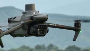
 In another version of the Mavic 3, DJI Agriculture has launched the Mavic 3 Multispectral for precision agriculture.
Continue reading below, or listen:
DJI Mavic 3 Multispectral carries a multispectral imaging system to collect the data used for crop monitoring. “Mavic 3 Multispectral is a must-have solution for a broad scope of application scenarios in the fields of precision agriculture and environmental monitoring,” says the announcement.
“The launch of DJI Mavic 3 Multispectral will help farmers around the world to improve the quality and efficiency of their production, reduce costs, and increase income, all while promoting the development of modern agriculture,” said Ronnie Liu, Regional Representative of North America at DJI Agriculture.
The Mavic 3 Multispectral is more portable than most drones for precision agriculture, weighing 951 grams and designed to fold and fit into an ordinary bag.
From DJI, the specs:
 RGB and Multispectral Imaging System
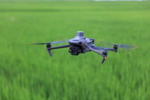
Mavic 3 Multispectral – also known as Mavic 3M – uses a two-in-one camera system to view and collect a wide array of information that users can turn into results on the field.
An RGB camera is equipped with a 4/3-inch CMOS and 20MP image sensor and mechanical shutter with a maximum speed of 1/2000. It manages high-speed continuous filming at the fastest interval of 0.7 seconds and can quickly collect image information, greatly improving the efficiency of operations over the fields.
In addition to the RGB camera, a four-lens multipectral camera provides more accurate directional information, helping users gain a deeper understanding of crop conditions by sensing details that the human eye cannot detect. Each of the four multispectral cameras of can capture 5 million pixels and scan for the following wavelengths:
- Green (G): 560nm ± 16nm
- Red (R): 650 nm ± 20 nm
- Red edge (RE): 730 nm ± 20 nm
- Near-infrared (NIR) 860 nm ± 26 nm
By combining these two cameras, Mavic 3M realizes applications such as high-precision aerial surveys, crop growth monitoring, and natural resource surveys.
RTK Centimeter-Level Positioning
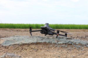
Mavic 3M includes an RTK module that achieves centimeter-level positioning. The drone, its camera, and the RTK module are synchronized at the microsecond level to accurately obtain the position information of the imaging center of each camera. This allows Mavic 3M to perform high-precision aerial surveying without the use of ground control points. And with a battery life of up to 43 minutes, Mavic 3M can complete the surveying and mapping operations of an area as vast as 2 square kilometers in a single flight.
Designed for Safer Operation
Mavic 3M is equipped with O3 video transmission, which integrates two channels of transmitting signals and four channels of receiving signals, and supports an ultra-long transmission distance of 15 kilometers. For added safety, Mavic 3M is equipped with omnidirectional obstacle sensing to detect obstacles in all directions and help avoid them accurately.
 Unlimited Possibilities
Helping professional users and partners in different fields, Mavic 3M can be integrated into various ecosystems to offer unlimited possibilities for smart agriculture. Through the built-in DJI Cloud API, based on the MQTT protocol in Pilot 2, users can directly connect Mavic 3M to a third-party cloud platform to collect information, live video, photo data, and other information, all without the need to develop a separate app. Mavic 3M also supports Mobile SDK 5 (MSDK5), letting users easily develop exclusive control apps for scenarios such as intelligent monitoring.
A New Tool for Precision Agriculture
Mavic 3M is useful in a multitude of work scenarios. It can conduct ground-like aerial surveys on mountain forests and orchards. The DJI Map and DJI SmartFarm Platform generate NDVI vegetation index to provide the data for more efficient and localized crop treatment. Automatic field scouting can detect crop abnormalities and perform intelligent analyses that allow a single person to manage 70 hectares of land.
Price and Availability
DJI Mavic 3 Multispectral is available for purchase today in select countries and regions. For more details about the product, pricing, and availability, visit https://ag.dji.com/mavic-3-m or contact an authorized local DJI reseller. Operators should check local regulations to determine what certifications and approvals are required to operate this product in their country or region.
Read more:
Miriam McNabb is the Editor-in-Chief of DRONELIFE and CEO of JobForDrones, a professional drone services marketplace, and a fascinated observer of the emerging drone industry and the regulatory environment for drones. Miriam has penned over 3,000 articles focused on the commercial drone space and is an international speaker and recognized figure in the industry. Miriam has a degree from the University of Chicago and over 20 years of experience in high tech sales and marketing for new technologies.
For drone industry consulting or writing, Email Miriam.
TWITTER:@spaldingbarker
Subscribe to DroneLife here.
https://dronelife.com/2022/11/27/dji-agriculture-launches-mavic-3-multispectral/


