 A DRONELIFE exclusive interview with Margherita Bruscolini of GLOBHE about her work in providing the vital information that disaster management teams around the world need to save lives and land.
Continue reading below, or listen:
Margherita Bruscolini is the Global Head of Drones, leading the client delivery team at GLOBHE, the impact tech company using drone data to help stakeholders understand the planet.
As climate change leads to more and more deadly climate events, that data serves a critical role in disaster management. A drone pilot with a background in geology and environmental science, Margherita Bruscolini is a committed advocate for technology solutions to meet environmental issues.
“I am passionate about using innovation and technology to tackle global challenges,” said Bruscolini. “We’re using tools that can really change things and have a positive impact on meeting the challenges of climate change.”
Local Impact, Global Purpose
Bruscolini’s team organizes drone operations globally, working with local teams of trained and licensed pilots to deliver critical drone data for global corporations or relief organizations. Bruscolini makes the connection between clients and local drone pilots, ensuring that the deliverables match project requirements. It’s a model that generates value for all stakeholders, and it’s a pillar of GLOBHE’s business.
“Our business model takes into account that we want to use local operators all over the world,” Bruscolini explained. “Having global coverage is great for clients, but it also creates a positive impact and business opportunities for pilots living in the remotest corner of the world.”
“That’s very important for us, we’re very passionate about creating a positive impact for communities in remote areas and developing countries, where there may be fewer opportunities for professional drone pilots. This also allows me to get in touch with different cultures and different experiences – for me its also a personal passion.”
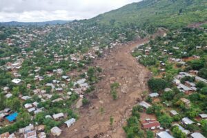
Managing Floods in Malawi: Prevention, Response, and Recovery
Managing disasters is a complex process, Bruscolini said: and drone data can add value throughout the disaster management ecosystem, from prevention to recovery.
“When we talk about a disaster, like a flood or a landslide – extreme weather events – there are different stages in the process,” she said. “Drones are powerful and flexible tools in disaster. At GLOBHE, we are active in all three steps – prevention, response, recovery.”
Prevention
Drones can help prevent damage by providing data on water levels, weather patterns, and ground conditions before a disaster hits. “We can help communities establish early warning systems by monitoring these conditions over time, helping identify extreme weather events in advance,” Bruscolini explained. “These early warning systems are really helpful. For example, flood risk maps can be produced using drone data complemented with satellite data. Modeling can simulate the state of rivers and predict how they will develop during weather events. We can create maps that show the areas that are most vulnerable so that the communities can take action to mitigate the effect of a flood.”
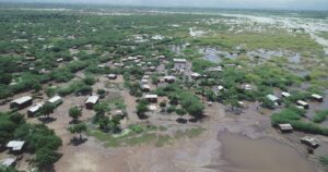
In November 2022, GLOBHE began working on flood prevention projects in Malawi, in collaboration with Unicef and other global partners. Flood risk mapping and modeling requires a high level of precision, and GLOBHE provided a team of local trained and licensed drone operators to produce high resolution orthomosaic maps, digital elevation models, and digital terrain models.
An important component of the project was communicating with local residents about the project. “Drones can really engage communities,” Bruscolini explained. “This can create positive effects by helping communities understand the risk of flooding, and also give them the tools to prepare. We make sure that we communicate about what we are going to do with the drones before we go out, we work to find creative ways to engage.”
In Malawi, the team came up with a novel solution for spreading information. The project required the use of GCPs and a GNSS station to measure accurate positions. For communities not familiar with drone operations, ground control points (GCPs) can look like targets, alarming local residents. “We needed to find a way to communicate – so we created a short jingle that played on the radio to inform communities, letting them know what the plan was and explaining what GCPs are for,” said Bruscolini.
Vulnerability maps help governments and organizations make development plans for flood management and allocate resources effectively. The maps also provide critical tools for planning and zoning in vulnerable areas. Continual monitoring as urban areas develop can help guard against disasters, like the many building collapses during Turkey’s earthquake earlier this year. “Urban development has to take environmental factors into consideration,” said Bruscolini.
Response
“In a crisis, drones are capable of providing a lot of assistance in disaster response, search and rescue. Drones can get past roadblocks: and equipped with cameras, thermal and LiDAR, they can be deployed very quickly for search and rescue to locate people who need assistance,” Bruscolini explained.
During the March 2023 flood events in Malawi, GLOBHE was again called on to collaborate with Unicef. “In 24 hours we deployed 8 skilled local drone operators to support disaster management and response, carrying out real time search and rescue missions,” said Bruscolini. “Our drone operators worked to identify vulnerable people, streaming imagery to rescue teams and supporting the activity of the emergency operation center.”
Working closely with Unicef and Red Cross Malawi, the team faced several challenges during the response phase: accessibility was difficult due to blocked roads and damaged infrastructure, and many areas were affected by landslides. Operators had to walk long distances to access the worst hit regions. Weather provided another challenge. During the cyclone weather event, the region was battered by heavy rain and winds, and many areas lost electricity. Local residents contributed by identifying power sources and resources for the operations team. “That’s when the community can really help, and it’s important to have local drone operators who can ask,” said Bruscolini.
Recovery
Drones can rapidly assess damage to infrastructure and buildings, providing situational awareness to response teams. Drones can safely assess the structural integrity of buildings and locate resources. Maps and images can be used for planning and monitoring recovery operations. For property and land owners, drone data provides important documentation after an extreme weather event. “Documenting the extent of the damage expedites insurance claims and speeds up recovery for the population,” said Bruscolini.
For Margherita Bruscolini, her job at GLOBHE allows her to do meaningful work that combines her passion for the environment and the global community with a love for technology.
“I always wanted to experience different backgrounds and perspectives,” said Bruscolini. “I think that’s fundamental, to get perspectives from different angles and different disciplines to solve problems. Having global coverage but focusing on local drone operators and local drone companies is an ideal combination.”
“I can feel that I am doing something and moving in the right direction,” she said. “At GLOBHE, we’re growing and we’re making even more impact. It’s an exciting time.”
Read more:
Miriam McNabb is the Editor-in-Chief of DRONELIFE and CEO of JobForDrones, a professional drone services marketplace, and a fascinated observer of the emerging drone industry and the regulatory environment for drones. Miriam has penned over 3,000 articles focused on the commercial drone space and is an international speaker and recognized figure in the industry. Miriam has a degree from the University of Chicago and over 20 years of experience in high tech sales and marketing for new technologies.
For drone industry consulting or writing, Email Miriam.
TWITTER:@spaldingbarker
Subscribe to DroneLife here.
https://dronelife.com/2023/06/05/prevention-response-and-recovery-globhe-uses-drones-to-manage-disasters-around-the-world/


